IMAGES TAKEN NEAR TO
Highfield Avenue, WARRINGTON, WA4 5DT
Introduction
This page details the photographs taken nearby to Highfield Avenue, WA4 5DT by members of the Geograph project.
The Geograph project started in 2005 with the aim of publishing, organising and preserving representative images for every square kilometre of Great Britain, Ireland and the Isle of Man.

There are currently over 7.5m images from over14,400 individuals and you can help contribute to the project by visiting https://www.geograph.org.uk
Image Map
Images are licensed for reuse under creativecommons.org/licenses/by-sa/2.0
Notes
- Clicking on the map will re-center to the selected point.
- The higher the marker number, the further away the image location is from the centre of the postcode.
Image Listing (8 Images Found)
Images are licensed for reuse under creativecommons.org/licenses/by-sa/2.0
Image
Details
Distance
1
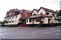
Dudlow's Green Road
Looking west to London Road [A49].
Image: © M J Richardson
Taken: 14 May 2011
0.06 miles
2

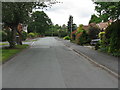
Beechways, from Dudlow Green Road
One of several tree-themed streetnames in the area.
Image: © M J Richardson
Taken: 14 May 2011
0.08 miles
3
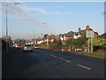
London Road (A49) at Dudlow Green Road
Image: © Peter Whatley
Taken: 17 Jan 2012
0.10 miles
4

London Road follows the course of a Roman road
Image: © Ian Greig
Taken: 10 Apr 2015
0.15 miles

6
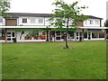
Shops at Dudlow's Green
Hairdresser, Dental Clinic, The co-operative, and Appleton NHS Primary Care.
Image: © M J Richardson
Taken: 14 May 2011
0.18 miles
7

Pineways at Dudlow's Green
Suburban housing estate with tree-themed street names.
Image: © M J Richardson
Taken: 14 May 2011
0.18 miles