IMAGES TAKEN NEAR TO
Yew Tree Lane, WARRINGTON, WA4 4QZ
Introduction
This page details the photographs taken nearby to Yew Tree Lane, WA4 4QZ by members of the Geograph project.
The Geograph project started in 2005 with the aim of publishing, organising and preserving representative images for every square kilometre of Great Britain, Ireland and the Isle of Man.

There are currently over 7.5m images from over14,400 individuals and you can help contribute to the project by visiting https://www.geograph.org.uk
Image Map
Images are licensed for reuse under creativecommons.org/licenses/by-sa/2.0
Notes
- Clicking on the map will re-center to the selected point.
- The higher the marker number, the further away the image location is from the centre of the postcode.
Image Listing (6 Images Found)
Images are licensed for reuse under creativecommons.org/licenses/by-sa/2.0
Image
Details
Distance
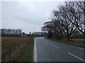
1
Junction of Grappenhall Lane and New Lane
Image: © Gary Rogers
Taken: 28 Mar 2018
0.08 miles
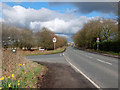
3
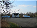
Burger Van
A Burger Van on a bit of old road off Grappenhall Lane. This is near a large estate of Industrial units. While it was not busy while I was there, I would imagine it could get quite busy at lunch times.
Image: © Mike Lyne
Taken: 1 Feb 2012
0.12 miles
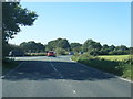
4
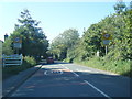
B5356 at Appleton Thorn village boundary
Image: © Colin Pyle
Taken: 21 Sep 2019
0.15 miles