IMAGES TAKEN NEAR TO
Weaste Lane, WARRINGTON, WA4 3JR
Introduction
This page details the photographs taken nearby to Weaste Lane, WA4 3JR by members of the Geograph project.
The Geograph project started in 2005 with the aim of publishing, organising and preserving representative images for every square kilometre of Great Britain, Ireland and the Isle of Man.

There are currently over 7.5m images from over14,400 individuals and you can help contribute to the project by visiting https://www.geograph.org.uk
Image Map
Images are licensed for reuse under creativecommons.org/licenses/by-sa/2.0
Notes
- Clicking on the map will re-center to the selected point.
- The higher the marker number, the further away the image location is from the centre of the postcode.
Image Listing (21 Images Found)
Images are licensed for reuse under creativecommons.org/licenses/by-sa/2.0
Image
Details
Distance
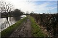
1
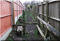
Footpath off Weaste Lane
This path between houses leads into fields to meet the A50 busy main road. I don't know what purpose the stile serves other than to give unwanted visitors a leg up into people's gardens.
Image: © michael ely
Taken: 11 Jan 2015
0.08 miles
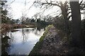
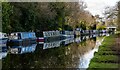
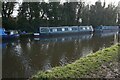
5
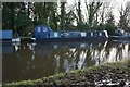
Bridgewater Canal towards Knutsford Road Bridge
Image: © Ian S
Taken: 1 Mar 2022
0.17 miles
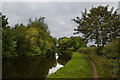
9

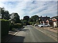
Cyclist on Pickerings Bridge
The bridge crosses the Bridgewater Canal,
Image: © michael ely
Taken: 18 Jun 2023
0.21 miles