IMAGES TAKEN NEAR TO
Australia Lane, WARRINGTON, WA4 3EZ
Introduction
This page details the photographs taken nearby to Australia Lane, WA4 3EZ by members of the Geograph project.
The Geograph project started in 2005 with the aim of publishing, organising and preserving representative images for every square kilometre of Great Britain, Ireland and the Isle of Man.

There are currently over 7.5m images from over14,400 individuals and you can help contribute to the project by visiting https://www.geograph.org.uk
Image Map
Images are licensed for reuse under creativecommons.org/licenses/by-sa/2.0
Notes
- Clicking on the map will re-center to the selected point.
- The higher the marker number, the further away the image location is from the centre of the postcode.
Image Listing (15 Images Found)
Images are licensed for reuse under creativecommons.org/licenses/by-sa/2.0
Image
Details
Distance
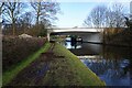
1
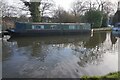
The Bridgewater Canal at Grappenhall
Looking west between Knutsford Road and Grappenhall Bridges [18 and 17].
Image: © Christine Johnstone
Taken: 30 May 2021
0.11 miles
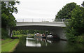
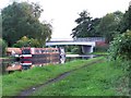
3
Bridgewater Canal: Knutsford Road Bridge No 18
Image: © Dr Neil Clifton
Taken: 29 Mar 2015
0.18 miles
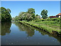
4
Bridgewater Canal towards Knutsford Road Bridge
Image: © Ian S
Taken: 1 Mar 2022
0.18 miles
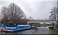
5
Cliff Lane Bridge
Carries A50 Knutsford Road over Bridgewater Canal
Image: © Mike Todd
Taken: 12 Jun 2011
0.19 miles
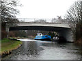
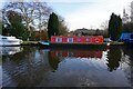
6
Bridgewater Canal
The"Blue Belle" is moored where the A50 spans the canal near Grappenhall.
Image: © michael ely
Taken: 11 Jan 2015
0.20 miles
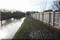
9
Knutsford Road Bridge over Bridgewater Canal
Image: © David Martin
Taken: 31 Jul 2010
0.22 miles