IMAGES TAKEN NEAR TO
Dale Lane, WARRINGTON, WA4 3DX
Introduction
This page details the photographs taken nearby to Dale Lane, WA4 3DX by members of the Geograph project.
The Geograph project started in 2005 with the aim of publishing, organising and preserving representative images for every square kilometre of Great Britain, Ireland and the Isle of Man.

There are currently over 7.5m images from over14,400 individuals and you can help contribute to the project by visiting https://www.geograph.org.uk
Image Map
Images are licensed for reuse under creativecommons.org/licenses/by-sa/2.0
Notes
- Clicking on the map will re-center to the selected point.
- The higher the marker number, the further away the image location is from the centre of the postcode.
Image Listing (18 Images Found)
Images are licensed for reuse under creativecommons.org/licenses/by-sa/2.0
Image
Details
Distance
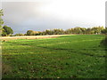
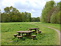
3
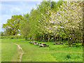
Picnic benches at Lumb Brook Millennium Green
Image: © Gary Rogers
Taken: 2 May 2018
0.11 miles
5
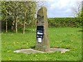
Standing Stone at Lumb Brook Millennium Green
Image: © Gary Rogers
Taken: 2 May 2018
0.12 miles
6
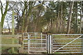
Opening gambit
A kissing gate invites walkers to stroll through the woods to Grappenhall.
Image: © David Long
Taken: 20 Jan 2006
0.13 miles
7
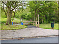
Footpath from Dale Lane to Lumb Brook Millennium Green
Image: © Gary Rogers
Taken: 2 May 2018
0.13 miles
9
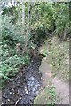
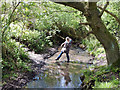
Lumb Brook
The brook has a bed of solid rock here, near the Lumb Brook Millennium Green.
Image: © Dave Dunford
Taken: 19 Sep 2009
0.15 miles