IMAGES TAKEN NEAR TO
Southway Avenue, WARRINGTON, WA4 3AF
Introduction
This page details the photographs taken nearby to Southway Avenue, WA4 3AF by members of the Geograph project.
The Geograph project started in 2005 with the aim of publishing, organising and preserving representative images for every square kilometre of Great Britain, Ireland and the Isle of Man.

There are currently over 7.5m images from over14,400 individuals and you can help contribute to the project by visiting https://www.geograph.org.uk
Image Map
Images are licensed for reuse under creativecommons.org/licenses/by-sa/2.0
Notes
- Clicking on the map will re-center to the selected point.
- The higher the marker number, the further away the image location is from the centre of the postcode.
Image Listing (7 Images Found)
Images are licensed for reuse under creativecommons.org/licenses/by-sa/2.0
Image
Details
Distance
1
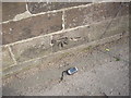
Cut Mark: #185 London Road, Stockton Heath
OS Cut Mark on the roadside wall outside #185 London Road, Stockton Heath. Number B11047 on the Benchmark Database, see http://www.bench-marks.org.uk/bm37396
Image: © VBForever
Taken: 25 Mar 2011
0.14 miles
2
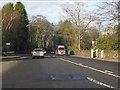
London Road (A49) at Delphfields Road
Image: © Peter Whatley
Taken: 17 Jan 2012
0.14 miles
3
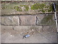
Cut Mark: London Road, Stockton Heath
OS Cut Mark on a sandstone roadside wall on London Road, Stockton Heath. Number B11046 on the Benchmark Database, see http://www.bench-marks.org.uk/bm37395
Image: © VBForever
Taken: 25 Mar 2011
0.19 miles
4
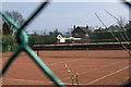
Peering through the wire fence at Stockton Heath Lawn Tennis Club
Image: © Ian Greig
Taken: 10 Apr 2015
0.23 miles
5
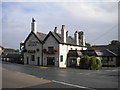
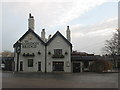
The London Bridge, Stockton Heath
A pub on London Road, immediately south to the bridge carrying that road across the Bridgewater Canal, hence the name.
Image: © Richard Vince
Taken: 12 Sep 2015
0.24 miles
7
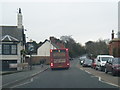
London Road southbound at London Bridge public house
Image: © Colin Pyle
Taken: 14 Jan 2015
0.25 miles