IMAGES TAKEN NEAR TO
Brookside Avenue, WARRINGTON, WA4 2XG
Introduction
This page details the photographs taken nearby to Brookside Avenue, WA4 2XG by members of the Geograph project.
The Geograph project started in 2005 with the aim of publishing, organising and preserving representative images for every square kilometre of Great Britain, Ireland and the Isle of Man.

There are currently over 7.5m images from over14,400 individuals and you can help contribute to the project by visiting https://www.geograph.org.uk
Image Map
Images are licensed for reuse under creativecommons.org/licenses/by-sa/2.0
Notes
- Clicking on the map will re-center to the selected point.
- The higher the marker number, the further away the image location is from the centre of the postcode.
Image Listing (7 Images Found)
Images are licensed for reuse under creativecommons.org/licenses/by-sa/2.0
Image
Details
Distance
1
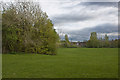
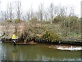
The Manchester Ship Canal
Looking east from the London Road Bridge at Wilderspool. An interesting comparison with Image, taken in 1994. The canal-side vegetation has grown quite considerably. The bridges in the distance are the Cantilever, with Ackers Road [1100 m away] and the Knutsford Road [A50] Swing Bridge 1600 m away].
Image: © M J Richardson
Taken: 15 May 2011
0.11 miles
2
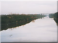
Manchester Ship Canal beacon 242
On the north bank, east of the London Road swingbridge.
Image: © Christine Johnstone
Taken: 13 Apr 2013
0.14 miles
3
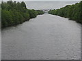
Manchester Ship Canal at Wilderspool
The canal was virtually disused at the time this photo was taken in 1994 but has since enjoyed something of a comeback.
Image: © Stephen Craven
Taken: 15 Jan 1994
0.18 miles
4
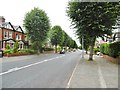
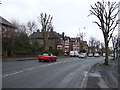
Stockton Heath, Grappenhall Road
A56, looking towards the village centre. This section of road is lined with trees and larger detached or semi-detached houses.
Image: © Mike Faherty
Taken: 4 Aug 2015
0.21 miles