IMAGES TAKEN NEAR TO
Gateley Close, WARRINGTON, WA4 2WN
Introduction
This page details the photographs taken nearby to Gateley Close, WA4 2WN by members of the Geograph project.
The Geograph project started in 2005 with the aim of publishing, organising and preserving representative images for every square kilometre of Great Britain, Ireland and the Isle of Man.

There are currently over 7.5m images from over14,400 individuals and you can help contribute to the project by visiting https://www.geograph.org.uk
Image Map
Images are licensed for reuse under creativecommons.org/licenses/by-sa/2.0
Notes
- Clicking on the map will re-center to the selected point.
- The higher the marker number, the further away the image location is from the centre of the postcode.
Image Listing (37 Images Found)
Images are licensed for reuse under creativecommons.org/licenses/by-sa/2.0
Image
Details
Distance
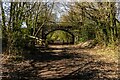
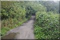
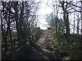
2
Thelwall to Bridgewater Canal road
Where it crossed the railway between Warrington and Altrincham, now a cycle path.
Image: © Richard Webb
Taken: 11 Aug 2019
0.09 miles
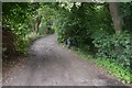
5
Thelwall to Bridgewater Canal road
A short link to the canal south of the village.
Image: © Richard Webb
Taken: 11 Aug 2019
0.11 miles
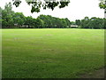
6
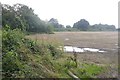
Stubble, Thelwall
The Bridgewater Canal is in the background on an embankment.
Image: © Richard Webb
Taken: 11 Aug 2019
0.12 miles
8
The Bridgewater Canal
From Pickering's Bridge.
Image: © JThomas
Taken: 2 Mar 2013
0.13 miles
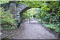
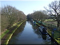
10
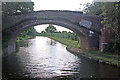
Pickering's Bridge, Bridgewater Canal
Although the Bridgewater was amongst the very earliest canals in Britain, it was built to standards that later canals failed to emulate - wide, lock-free and, wherever possible, straight. It is now exclusively a leisure waterway, but is operated by the Manchester Ship Canal Company rather than British Waterways.
Image: © Stephen McKay
Taken: 29 Aug 2010
0.14 miles