IMAGES TAKEN NEAR TO
Stockport Road, WARRINGTON, WA4 2SZ
Introduction
This page details the photographs taken nearby to Stockport Road, WA4 2SZ by members of the Geograph project.
The Geograph project started in 2005 with the aim of publishing, organising and preserving representative images for every square kilometre of Great Britain, Ireland and the Isle of Man.

There are currently over 7.5m images from over14,400 individuals and you can help contribute to the project by visiting https://www.geograph.org.uk
Image Map
Images are licensed for reuse under creativecommons.org/licenses/by-sa/2.0
Notes
- Clicking on the map will re-center to the selected point.
- The higher the marker number, the further away the image location is from the centre of the postcode.
Image Listing (31 Images Found)
Images are licensed for reuse under creativecommons.org/licenses/by-sa/2.0
Image
Details
Distance
3
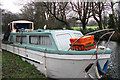
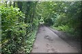
Halfacre Lane Aqueduct
This photo was taken from the bridge carrying the Trans Pennine Train over Halfacre Lane, which is visible in the photograph. The bridge in the photo carries the Bridgewater Canal over Halfacre Lane.
Image: © Richard Cooke
Taken: 2 Jan 2015
0.09 miles
4
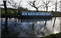
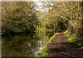
Bridgewater Canal
Moored up for the winter. Pointing towards Grappenhall.
Image: © michael ely
Taken: 11 Jan 2015
0.10 miles
7

Inscription on the plinth of Thelwall War Memorial
Image: © Ian Greig
Taken: 12 Sep 2014
0.15 miles
9

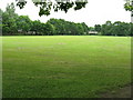
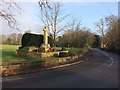
Playing field and War Memorial at Thelwall
Image: © Ian Greig
Taken: 12 Sep 2014
0.16 miles
10
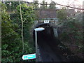
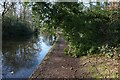
Trans Pennine Trail, Thelwall
Closed to passengers in 1962, the railway continued as a freight line until 1985. Now a rails to trails conversion giving a traffic free route between Warrington and Altrincham.
The closure was probably precipitated by the need to renovate the Latchford Viaduct. At that time one of the Stupid's big ideas was an ideological loathing of railways. Even the Forth Bridge (same engineers, Arrols) was considered for closure.
Image: © Richard Webb
Taken: 11 Aug 2019
0.17 miles