IMAGES TAKEN NEAR TO
Chester Road, WARRINGTON, WA4 2RZ
Introduction
This page details the photographs taken nearby to Chester Road, WA4 2RZ by members of the Geograph project.
The Geograph project started in 2005 with the aim of publishing, organising and preserving representative images for every square kilometre of Great Britain, Ireland and the Isle of Man.

There are currently over 7.5m images from over14,400 individuals and you can help contribute to the project by visiting https://www.geograph.org.uk
Image Map
Images are licensed for reuse under creativecommons.org/licenses/by-sa/2.0
Notes
- Clicking on the map will re-center to the selected point.
- The higher the marker number, the further away the image location is from the centre of the postcode.
Image Listing (17 Images Found)
Images are licensed for reuse under creativecommons.org/licenses/by-sa/2.0
Image
Details
Distance
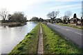
2
View from Lumbbrook Bridge
Lumbbrook Bridge is an aqueduct carrying the Bridgewater Canal over Lumb Brook Road. The parapet offers a surprisingly wide view over Warrington and the Mersey valley.
Image: © Dave Dunford
Taken: 19 Sep 2009
0.12 miles
3
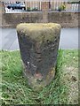
Old Milestone by the A56 in Stockton Heath
Carved stone post by the A56, in parish of Stockton Heath (Warrington District), Chester Road, Lumbrook, at junction with Lumb Brook Road on verge, on South side of road. Warrington flat top, erected by the Frodsham & Wilderspool turnpike trust in the 18th century.
Inscription reads:-
: (To / Runcorn 7) : : TO / M(an)che(s)ter / (18) :
Milestone Society National ID: CH_MARC18
Image: © M Faherty
Taken: 4 Aug 2015
0.13 miles
4
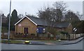
Stockton Heath, Bethesda Evangelical Church
On Chester Road: http://www.bethesdaevangelical.org.uk/
Image: © Mike Faherty
Taken: 4 Aug 2015
0.13 miles
6
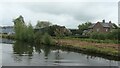
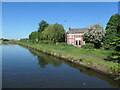
Mountain Farm, Stockton Lane
On the south bank of the Bridgwater Canal. Shown on the 18070s large-scale OS map. On flat land about 25 metres above sea level.
Image: © Christine Johnstone
Taken: 22 May 2021
0.13 miles
9
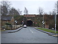
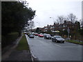
Lumb Brook Road
The bridge ahead carries the Bridgewater Canal.
Image: © JThomas
Taken: 9 Mar 2013
0.15 miles
10
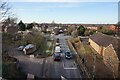
Semi-detached houses, Chester Road, Grappenhall
On the north bank of the Bridgewater Canal.
Image: © Christine Johnstone
Taken: 30 May 2021
0.15 miles