IMAGES TAKEN NEAR TO
Wash Lane, WARRINGTON, WA4 2RT
Introduction
This page details the photographs taken nearby to Wash Lane, WA4 2RT by members of the Geograph project.
The Geograph project started in 2005 with the aim of publishing, organising and preserving representative images for every square kilometre of Great Britain, Ireland and the Isle of Man.

There are currently over 7.5m images from over14,400 individuals and you can help contribute to the project by visiting https://www.geograph.org.uk
Image Map
Images are licensed for reuse under creativecommons.org/licenses/by-sa/2.0
Notes
- Clicking on the map will re-center to the selected point.
- The higher the marker number, the further away the image location is from the centre of the postcode.
Image Listing (30 Images Found)
Images are licensed for reuse under creativecommons.org/licenses/by-sa/2.0
Image
Details
Distance
2
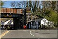
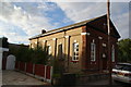
Wash Lane Railway Bridge
Bridge carrying the (now dismantled) railway line over Wash Lane.
Image: © David Dixon
Taken: 27 Jul 2012
0.01 miles
3
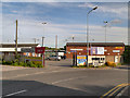
Warrington Town AFC
The entrance to the Warringtin Town Football Club.
Image: © David Dixon
Taken: 27 Jul 2012
0.06 miles
4
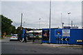
Entrance to the HG Driver Recruitment Stadium
The home of Warrington Town AFC who play in the Evo-Stik League First Division North.
Image: © Bill Boaden
Taken: 5 Oct 2013
0.06 miles
5
Latchford Baptist Church
This is the original part of the church building, being the former Bethel Baptist Chapel dating from 1860. The church now has much more space in buildings behind this one.
Image: © Bill Boaden
Taken: 5 Oct 2013
0.07 miles
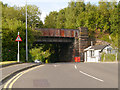
6
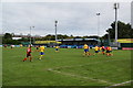
Football match at Warrington Town
The game is a tie in the FA Trophy. The bridge behind carries Ackers Road over the Manchester Ship Canal.
Image: © Bill Boaden
Taken: 5 Oct 2013
0.10 miles
7
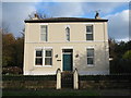
Brookfield, Wash Lane
Brookfield cottage in Wash Lane, the house is dated 1809 with the initials JH and predates the adjacent schoolroom and church. It is known that Joseph Hughes, a toolmaker, his brother John and wife Hannah lived in the house at the end of the 19th century.
Wash Lane was the old road to London and almost opposite stood the black and white half-timbered house known as the Plague House which was built in 1656 by Richard Warburton. It is likely that those who died of the plague here were not buried in the consecrated ground of the parish but interred in the field immediately behind the plague house, which was at the time glebe land. No doubt this accounted for the human remains discovered in the mid 19th century and plotted on the 1875 map. The plague house was demolished in 1957.
More information:- https://deathsplaining.wordpress.com/2014/01/14/the-plague-house/
Image: © Sue Adair
Taken: 3 Nov 2019
0.10 miles
8
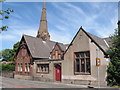
Christ Church and Wash Lane Schoolroom
Wash Lane Schoolroom was built in 1844 by Thomas Greenall as a much needed infants’ school in this rural area. In 1872 it was extended and its status changed to a Mixed School, having the services of both a master and a school-mistress and around this time the school had to be closed many times due to flooding from the river in Wash Lane. It continued to be used as a school until 31st March 1913 and since then Christ Church has used the building for various parish activities.
Image: © Sue Adair
Taken: 8 Jun 2008
0.12 miles
9
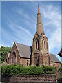
Christ Church, Latchford
Christ Church, Latchford on Wash Lane was consecrated on 16 July 1861.
Image: © Sue Adair
Taken: 8 Jun 2008
0.13 miles
10
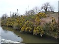
Flowering gorse along the Manchester Ship Canal
On the north bank, just west of Latchford High Level bridge.
Image: © Christine Johnstone
Taken: 13 Apr 2013
0.13 miles