IMAGES TAKEN NEAR TO
Ashley Close, WARRINGTON, WA4 2RB
Introduction
This page details the photographs taken nearby to Ashley Close, WA4 2RB by members of the Geograph project.
The Geograph project started in 2005 with the aim of publishing, organising and preserving representative images for every square kilometre of Great Britain, Ireland and the Isle of Man.

There are currently over 7.5m images from over14,400 individuals and you can help contribute to the project by visiting https://www.geograph.org.uk
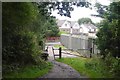
Image Map
Images are licensed for reuse under creativecommons.org/licenses/by-sa/2.0
Notes
- Clicking on the map will re-center to the selected point.
- The higher the marker number, the further away the image location is from the centre of the postcode.
Image Listing (41 Images Found)
Images are licensed for reuse under creativecommons.org/licenses/by-sa/2.0
Image
Details
Distance

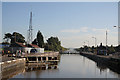
2
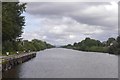
Manchester Ship Canal
East of Latchford Locks, seen from one of the gates. The bridge is the older of the pair of viaducts on the M6 at Thelwell.
Image: © Richard Webb
Taken: 11 Aug 2019
0.10 miles
3
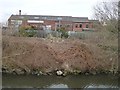
Beers Timber and Building Supplies
On the north bank of the Manchester Ship Canal. A large modern shed extends unseen behind the older brick building.
Image: © Christine Johnstone
Taken: 13 Apr 2013
0.12 miles
4
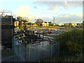
Aluminium recycling plant from across Latchford locks
Image: © Steven
Taken: 9 Nov 2005
0.13 miles
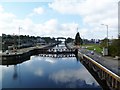
5
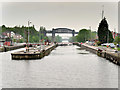
Manchester Ship Canal, Latchford Locks
In common with all the others on the canal, there are two lock chambers side by side at Latchford. The shorter one is for smaller vessels such as tugs and coasters, enabling them to pass through using less water that would be needed if they had to use the main lock.
The lift at Latchford is now 12 feet 6 inches, although it was originally sixteen feet six inches until 1909 when the canal was deepened to its present 28 foot clearance and the lift dropped to 14 foot 6. The lift was to be further reduced to its present level in 1956 when the water level was raised a further two feet between Eastham and Latchford.
The hydraulic machinery here also provides power for the swing bridges in the Warrington area.
https://web.archive.org/web/20081120203945/http://users.breathe.com/g8hxe/latchford_locks.htm (archived)
Image: © David Dixon
Taken: 11 May 2016
0.15 miles
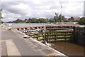
6
Latchford Locks
Looking towards Manchester with the M6 Thelwall viaduct in the distance.
Image: © Alan Murray-Rust
Taken: 6 Oct 2008
0.15 miles
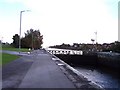
7
Lock gate, Latchford Locks
The eastern end with the older Thelwall Viaduct visible in the background.
Image: © Richard Webb
Taken: 11 Aug 2019
0.16 miles
8
Latchford Locks
The fourth set of locks on Manchester Ship Canal from Salford, giving a drop of 12'6". http://users.breathe.com/g8hxe/latchford_locks.htm
Image: © Mike Faherty
Taken: 18 Sep 2011
0.16 miles
10
The Trans Pennine Trail leaves the railway
With Latchford Viaduct out of action - the probable cause of the line's closure in 1985 along with the ideological stupidity of the government of the time, the path descends to the suburban road network of Warrington.
Image: © Richard Webb
Taken: 11 Aug 2019
0.18 miles