IMAGES TAKEN NEAR TO
Cawthorne Avenue, WARRINGTON, WA4 2LP
Introduction
This page details the photographs taken nearby to Cawthorne Avenue, WA4 2LP by members of the Geograph project.
The Geograph project started in 2005 with the aim of publishing, organising and preserving representative images for every square kilometre of Great Britain, Ireland and the Isle of Man.

There are currently over 7.5m images from over14,400 individuals and you can help contribute to the project by visiting https://www.geograph.org.uk
Image Map
Images are licensed for reuse under creativecommons.org/licenses/by-sa/2.0
Notes
- Clicking on the map will re-center to the selected point.
- The higher the marker number, the further away the image location is from the centre of the postcode.
Image Listing (48 Images Found)
Images are licensed for reuse under creativecommons.org/licenses/by-sa/2.0
Image
Details
Distance
2
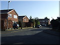
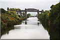
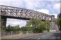
Latchford Viaduct
Once carrying the Warrington to Stockport railway line over Manchester Ship Canal. Opened 1893, line closed 1985. http://www.forgottenrelics.co.uk/bridges/gallery/latchford.html
Image: © Mike Faherty
Taken: 18 Sep 2011
0.08 miles
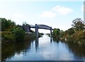
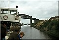
4
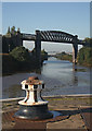
Latchford Lock, Manchester Ship Canal
Looking westwards at Latchford Lock, Warrington, towards Latchford railway bridge.
Image: © Martin Clark
Taken: Unknown
0.08 miles
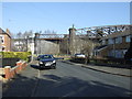
6
Manchester Ship Canal
View NE from Knutsford Road swing bridge towards the disused railway bridge and Latchford Locks
Image: © Richard Croft
Taken: 10 Sep 2010
0.09 miles
8
Latchford Viaduct and Locks ? 1978
Taken during one of the Mersey Ferries regular cruises along the Manchester Ship Canal. The viaduct carried the former London and North Western Railway line between Warrington and Stockport. Rail services on the line finished in 1985.
Image: © Alan Murray-Rust
Taken: Unknown
0.09 miles
9
Manchester Ship Canal at Latchford
Looking towards Liverpool. The nearest bridge carried the former LNWR railway line from Ditton Junction (near Widnes) to Timperley Junction (for Manchester). The line was dismantled many years ago.
Image: © Alan Murray-Rust
Taken: 6 Oct 2008
0.09 miles
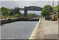
10
Latchford Viaduct
A high railway bridge over the Manchester Ship Canal with the same engineers as the Forth Bridge, Arrol. Closed in 1985 because of maintenance and renovation costs. At the time there was even talk of closing Arrol's best known construction The Forth Bridge.
Today it is closed to all traffic and the Trans Pennine Trail uses the B5157.
Image: © Richard Webb
Taken: 11 Aug 2019
0.09 miles