IMAGES TAKEN NEAR TO
Walden Close, WARRINGTON, WA4 2HB
Introduction
This page details the photographs taken nearby to Walden Close, WA4 2HB by members of the Geograph project.
The Geograph project started in 2005 with the aim of publishing, organising and preserving representative images for every square kilometre of Great Britain, Ireland and the Isle of Man.

There are currently over 7.5m images from over14,400 individuals and you can help contribute to the project by visiting https://www.geograph.org.uk
Image Map
Images are licensed for reuse under creativecommons.org/licenses/by-sa/2.0
Notes
- Clicking on the map will re-center to the selected point.
- The higher the marker number, the further away the image location is from the centre of the postcode.
Image Listing (19 Images Found)
Images are licensed for reuse under creativecommons.org/licenses/by-sa/2.0
Image
Details
Distance
6
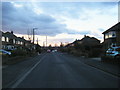
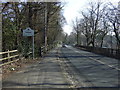
Stockport Road (A56), looking west at Stanton Road
Image: © Peter Whatley
Taken: 17 Jan 2012
0.16 miles
7
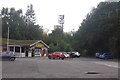
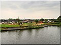
British Legion
Grappenhall and Thelwall Royal British Legion - games hall and car park.
Image: © Richard Webb
Taken: 11 Aug 2019
0.18 miles
8
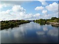
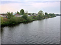
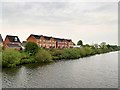
Woolston, Manchester Ship Canal
With Thelwall High Level Bridge, and chimneys at Latchford in the distance.
Image: © Mike Faherty
Taken: 18 Sep 2011
0.19 miles
9
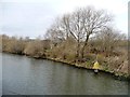
Manchester Ship Canal beacon 302
On the north bank.
Image: © Christine Johnstone
Taken: 13 Apr 2013
0.19 miles