IMAGES TAKEN NEAR TO
Hill Top Road, WARRINGTON, WA4 2DP
Introduction
This page details the photographs taken nearby to Hill Top Road, WA4 2DP by members of the Geograph project.
The Geograph project started in 2005 with the aim of publishing, organising and preserving representative images for every square kilometre of Great Britain, Ireland and the Isle of Man.

There are currently over 7.5m images from over14,400 individuals and you can help contribute to the project by visiting https://www.geograph.org.uk
Image Map
Images are licensed for reuse under creativecommons.org/licenses/by-sa/2.0
Notes
- Clicking on the map will re-center to the selected point.
- The higher the marker number, the further away the image location is from the centre of the postcode.
Image Listing (51 Images Found)
Images are licensed for reuse under creativecommons.org/licenses/by-sa/2.0
Image
Details
Distance
2
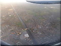
Aerial photograph of Manchester Ship Canal 13 February 2014
From an aircraft heading for Liverpool John Lennon Airport from Isle of Man.
The Chester road swing bridge is just below the centre of the image.
Image: © Richard Hoare
Taken: 13 Feb 2014
0.08 miles
4
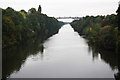
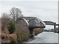
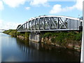
Manchester Ship Canal
Looking SW from Knutsford Road bridge
Image: © Richard Croft
Taken: 10 Sep 2010
0.10 miles
6
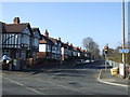
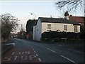
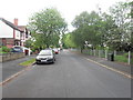
Greenbank Road, Warrington
Beside the Manchester Ship Canal.
Image: © JThomas
Taken: 2 Mar 2013
0.13 miles
7
Knutsford Road swingbridge closing
After a ship has passed westbound.
Image: © Christine Johnstone
Taken: 13 Apr 2013
0.13 miles
8
Knutsford Road swingbridge nearly closed
Having opened to let an eastbound ship pass along the Manchester Ship Canal.
Image: © Christine Johnstone
Taken: 13 Apr 2013
0.13 miles
9
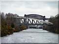
Warrington, swing bridge
Knutsford Road Swing Bridge, carrying A50 across Manchester Ship Canal; now open for shipping to pass through. http://homepages.tesco.net/frankshackleton/mscbridges/section5/section5.htm
Image: © Mike Faherty
Taken: 18 Sep 2011
0.14 miles
10
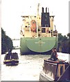
Ship Canal Centenary Fleet at Knutsford Road, 1994
The Ship Canal Company say narrow boats and ocean-going ships are a bad mix - but they let this vessel out of Latchford Lock as the Centenary Cruise approached. Steve Parish, on WIZARD, might well look back in wonder!
Image: © David Long
Taken: Unknown
0.14 miles