IMAGES TAKEN NEAR TO
Smithy Brow, WARRINGTON, WA3 7BY
Introduction
This page details the photographs taken nearby to Smithy Brow, WA3 7BY by members of the Geograph project.
The Geograph project started in 2005 with the aim of publishing, organising and preserving representative images for every square kilometre of Great Britain, Ireland and the Isle of Man.

There are currently over 7.5m images from over14,400 individuals and you can help contribute to the project by visiting https://www.geograph.org.uk
Image Map
Images are licensed for reuse under creativecommons.org/licenses/by-sa/2.0
Notes
- Clicking on the map will re-center to the selected point.
- The higher the marker number, the further away the image location is from the centre of the postcode.
Image Listing (5 Images Found)
Images are licensed for reuse under creativecommons.org/licenses/by-sa/2.0
Image
Details
Distance
1
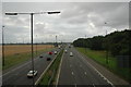
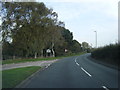
M6 near Winwick
This is a view looking south east down the M6 as it passes through Winwick near Warrington. The slip road that can be seen joining the right hand carriageway is from the M62.
Image: © andy
Taken: 20 Jul 2005
0.15 miles
2
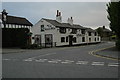
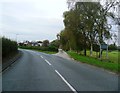
The Horse Shoe, Croft
This is the Horse Shoe pub at the junction of Smithy Brow, Lord Street and Smithy Lane in Croft near Warrington.
Image: © andy
Taken: 22 Jul 2005
0.23 miles