IMAGES TAKEN NEAR TO
Colebrooke Close, WARRINGTON, WA3 6RY
Introduction
This page details the photographs taken nearby to Colebrooke Close, WA3 6RY by members of the Geograph project.
The Geograph project started in 2005 with the aim of publishing, organising and preserving representative images for every square kilometre of Great Britain, Ireland and the Isle of Man.

There are currently over 7.5m images from over14,400 individuals and you can help contribute to the project by visiting https://www.geograph.org.uk
Image Map
Images are licensed for reuse under creativecommons.org/licenses/by-sa/2.0
Notes
- Clicking on the map will re-center to the selected point.
- The higher the marker number, the further away the image location is from the centre of the postcode.
Image Listing (29 Images Found)
Images are licensed for reuse under creativecommons.org/licenses/by-sa/2.0
Image
Details
Distance
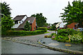
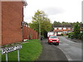
3
West end of McCarthy Close, Oakwood
One of several residential cul de sacs off Admirals Road.
Image: © Richard Vince
Taken: 12 Sep 2015
0.04 miles
4
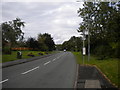
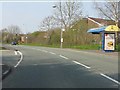
Admirals Road, Oakwood
The main distributor road through Oakwood, seen close to its eastern extremity.
Image: © Richard Vince
Taken: 12 Sep 2015
0.05 miles
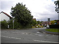
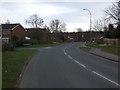
5
Admirals Road at the junction for Jay Close
Image: © Peter Whatley
Taken: 24 Mar 2011
0.06 miles
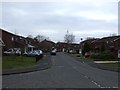
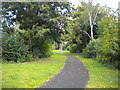
10
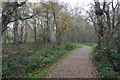
Footpath on Risley Moss
A very good footpath does a circuit of the woodland areas, but the wetland areas remain inaccessible to the public.
Image: © Bill Boaden
Taken: 31 Oct 2016
0.14 miles