IMAGES TAKEN NEAR TO
Nightingale Close, WARRINGTON, WA3 6PD
Introduction
This page details the photographs taken nearby to Nightingale Close, WA3 6PD by members of the Geograph project.
The Geograph project started in 2005 with the aim of publishing, organising and preserving representative images for every square kilometre of Great Britain, Ireland and the Isle of Man.

There are currently over 7.5m images from over14,400 individuals and you can help contribute to the project by visiting https://www.geograph.org.uk
Image Map
Images are licensed for reuse under creativecommons.org/licenses/by-sa/2.0
Notes
- Clicking on the map will re-center to the selected point.
- The higher the marker number, the further away the image location is from the centre of the postcode.
Image Listing (24 Images Found)
Images are licensed for reuse under creativecommons.org/licenses/by-sa/2.0
Image
Details
Distance
3
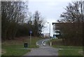
Dual use path off Ordnance Avenue
Towards the A574.
Image: © JThomas
Taken: 2 Mar 2013
0.17 miles
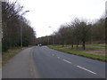
4
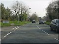
Admirals Road at the junction for Dunnock Grove
Image: © Peter Whatley
Taken: 24 Mar 2011
0.18 miles
5
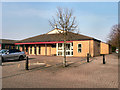
Church of the Transfiguration
The Church of the Transfiguration on Admirals Road, Birchwood.
Image: © David Dixon
Taken: 28 Mar 2011
0.18 miles
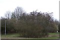
6

Autumn trees by Ordnance Avenue
A path runs roughly parallel to the road but not next to it.
Image: © Bill Boaden
Taken: 31 Oct 2016
0.18 miles
7
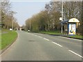
Admirals Road approaching Whinchat Drive
Image: © Peter Whatley
Taken: 24 Mar 2011
0.19 miles
8
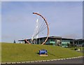
Connections
This is the Connections sculpture located as the entrance feature to Birchwood Park.
Image: © Dave Smethurst
Taken: 13 Jul 2005
0.20 miles
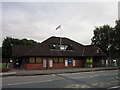
9
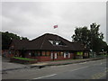
Upside down Union Flag #43
At Nelsons Quarterdeck public house
Image: © Ian S
Taken: 18 Jul 2012
0.20 miles