IMAGES TAKEN NEAR TO
Curlew Grove, WARRINGTON, WA3 6NX
Introduction
This page details the photographs taken nearby to Curlew Grove, WA3 6NX by members of the Geograph project.
The Geograph project started in 2005 with the aim of publishing, organising and preserving representative images for every square kilometre of Great Britain, Ireland and the Isle of Man.

There are currently over 7.5m images from over14,400 individuals and you can help contribute to the project by visiting https://www.geograph.org.uk
Image Map
Images are licensed for reuse under creativecommons.org/licenses/by-sa/2.0
Notes
- Clicking on the map will re-center to the selected point.
- The higher the marker number, the further away the image location is from the centre of the postcode.
Image Listing (16 Images Found)
Images are licensed for reuse under creativecommons.org/licenses/by-sa/2.0
Image
Details
Distance
1
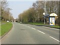
Admirals Road approaching Whinchat Drive
Image: © Peter Whatley
Taken: 24 Mar 2011
0.14 miles
2
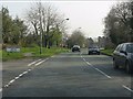
Admirals Road at the junction for Dunnock Grove
Image: © Peter Whatley
Taken: 24 Mar 2011
0.18 miles
3
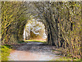
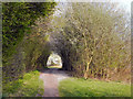
Birchwood Forest Park
Originally, this area was known as Risley. In 1939 the small farming community was transformed by the construction of Risley Royal Ordnance Factory which covered nearly 1000 acres of prime agricultural land and produced millions of bombs and shells during the Second World War.
After the war, the factory was used by the Admiralty as a storage depot until 1961. The new town of Birchwood and Birchwood Forest Park were created in the 1970s from one of the largest derelict land sites in Europe.
Image: © David Dixon
Taken: 28 Mar 2011
0.19 miles
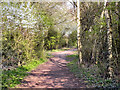
4
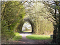
Birchwood Forest Park
Originally, this area was known as Risley. In 1939 the small farming community was transformed by the construction of Risley Royal Ordnance Factory which covered nearly 1000 acres of prime agricultural land and produced millions of bombs and shells during the Second World War.
After the war, the factory was used by the Admiralty as a storage depot until 1961. The new town of Birchwood and Birchwood Forest Park were created in the 1970s from one of the largest derelict land sites in Europe.
Image: © David Dixon
Taken: 28 Mar 2011
0.19 miles
5
Birchwood Forest Park
Originally, this area was known as Risley. In 1939 the small farming community was transformed by the construction of Risley Royal Ordnance Factory which covered nearly 1000 acres of prime agricultural land and produced millions of bombs and shells during the Second World War.
After the war, the factory was used by the Admiralty as a storage depot until 1961. The new town of Birchwood and Birchwood Forest Park were created in the 1970s from one of the largest derelict land sites in Europe.
Image: © David Dixon
Taken: 28 Mar 2011
0.19 miles
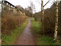
6
Birchwood Forest Park
Originally, this area was known as Risley. In 1939 the small farming community was transformed by the construction of Risley Royal Ordnance Factory which covered nearly 1000 acres of prime agricultural land and produced millions of bombs and shells during the Second World War.
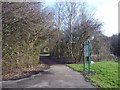
After the war, the factory was used by the Admiralty as a storage depot until 1961. The new town of Birchwood and Birchwood Forest Park were created in the 1970s from one of the largest derelict land sites in Europe. This is the path into the park from Dewhurst Road, near to Birchwood Station.
Image: © David Dixon
Taken: 28 Mar 2011
0.21 miles
7
Path, Oakwood
Path at the back of Lyster Close. Birchwood Forest Park is the name given to all the green areas throughout Birchwood. The town is made up of the three villages – Gorse Covert, Oakwood and Locking Stumps.
Image: © Nigel Homer
Taken: 29 Jan 2006
0.23 miles
8
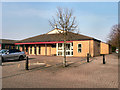
Church of the Transfiguration
The Church of the Transfiguration on Admirals Road, Birchwood.
Image: © David Dixon
Taken: 28 Mar 2011
0.23 miles
9
Birchwood Brook Park
Dewhurst Road entrance to Birchwood Brook Park, Oakwood nr Warrington - a February version.
Image: © Mike Harris
Taken: 18 Feb 2007
0.24 miles
10

Nelsons Quarterdeck, Birchwood
The Nelsons Quarterdeck, a public house on Admirals Road, near to the Birchwood Centre.
Image: © David Dixon
Taken: 28 Mar 2011
0.24 miles