IMAGES TAKEN NEAR TO
School Lane, WARRINGTON, WA3 6LH
Introduction
This page details the photographs taken nearby to School Lane, WA3 6LH by members of the Geograph project.
The Geograph project started in 2005 with the aim of publishing, organising and preserving representative images for every square kilometre of Great Britain, Ireland and the Isle of Man.

There are currently over 7.5m images from over14,400 individuals and you can help contribute to the project by visiting https://www.geograph.org.uk
Image Map
Images are licensed for reuse under creativecommons.org/licenses/by-sa/2.0
Notes
- Clicking on the map will re-center to the selected point.
- The higher the marker number, the further away the image location is from the centre of the postcode.
Image Listing (9 Images Found)
Images are licensed for reuse under creativecommons.org/licenses/by-sa/2.0
Image
Details
Distance
1
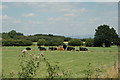
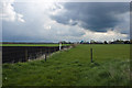
View across farm land near Gorse Covert, Warrington
This is a view looking north over farm land just to the east of Gorse Covert near Warrington. I would imagine that the livestock belong to either New Hall Farm or Hoyle's Moss Farm. To the left you can just make out the edge of a housing estate. The hill in the far distance is Winter Hill and if you look very carefully indeed you can just make out the large mast that is a land mark around these parts.
Image: © andy
Taken: 2 Aug 2005
0.04 miles
2
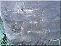
Ordnance Survey Cut Mark
This mark can be found on the wall of a building at New Hall Farm.
For more detail see : http://www.bench-marks.org.uk/bm45956
Image: © Peter Wood
Taken: 27 Oct 2012
0.08 miles
4
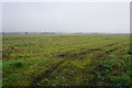
Pestfurlong Moss
Looking a bit more dormant now that autumn is taking hold.
Image: © Bill Boaden
Taken: 31 Oct 2016
0.17 miles
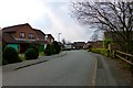
6
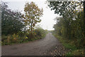
Track to New Hall Farm
There is a hint of autumn mist.
Image: © Bill Boaden
Taken: 31 Oct 2016
0.18 miles
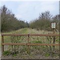
7
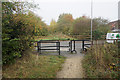
Footpath crossing Rockingham Close
Making use of a band of open land between new housing development.
Image: © Bill Boaden
Taken: 31 Oct 2016
0.22 miles