IMAGES TAKEN NEAR TO
Chapel Lane, WARRINGTON, WA3 6HG
Introduction
This page details the photographs taken nearby to Chapel Lane, WA3 6HG by members of the Geograph project.
The Geograph project started in 2005 with the aim of publishing, organising and preserving representative images for every square kilometre of Great Britain, Ireland and the Isle of Man.

There are currently over 7.5m images from over14,400 individuals and you can help contribute to the project by visiting https://www.geograph.org.uk
Image Map
Images are licensed for reuse under creativecommons.org/licenses/by-sa/2.0
Notes
- Clicking on the map will re-center to the selected point.
- The higher the marker number, the further away the image location is from the centre of the postcode.
Image Listing (16 Images Found)
Images are licensed for reuse under creativecommons.org/licenses/by-sa/2.0
Image
Details
Distance
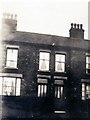
2
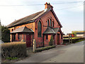
Bikers Church (Rixton Methodist Church)
The large notice board (Image]) proclaims this as "Bikers Church". However Rixton Methodist Church has not closed! The new Bikers Church notice board is merely advertising the fact that they have invited the Christian Motorcyclist Association to use their building for their services. (http://www.hollinsgreen.net/assets/winterITK2010/winterITK12010.pdf - Rixton with Glazebrook newsletter, Winter 2010)
Image: © David Dixon
Taken: 24 Mar 2011
0.02 miles
3
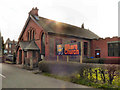
Ordnance Survey Cut Mark
This mark can be found on the wall of The Bikers Church.
For more detail see : http://www.bench-marks.org.uk/bm45954
Image: © Peter Wood
Taken: 27 Oct 2012
0.03 miles
4
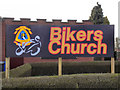
Bikers Church Noticeboard
The large noticeboard outside Image], on Chapel Lane, advertising the fact that the church has invited the Christian Motorcyclist Association to use their building for their services. (http://www.hollinsgreen.net/assets/winterITK2010/winterITK12010.pdf - Rixton with Glazebrook newsletter, Winter 2010)
Image: © David Dixon
Taken: 24 Mar 2011
0.03 miles
6
St Michael?s Chapel
St Michael’s Chapel on Moss Side Lane used to be the Roman Catholic place of worship for local residents in Hollins Green and Glazebrook until it was sold in the 1980s
Image: © David Dixon
Taken: 24 Mar 2011
0.11 miles
8
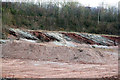
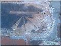
Clay beds in a former clay pit
Extraction of clay has revealed a fine set of alternating grey and red clay beds, resting at a considerable angle. The pit is gradually being backfilled so these will eventually disappear.
Image: © Alan Murray-Rust
Taken: 8 Apr 2013
0.12 miles
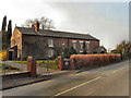
9

Cleveland's Farm
Buildings at Cleveland's Farm.
Image: © Peter McDermott
Taken: 11 Oct 2014
0.14 miles