IMAGES TAKEN NEAR TO
Moss Side Lane, WARRINGTON, WA3 6EN
Introduction
This page details the photographs taken nearby to Moss Side Lane, WA3 6EN by members of the Geograph project.
The Geograph project started in 2005 with the aim of publishing, organising and preserving representative images for every square kilometre of Great Britain, Ireland and the Isle of Man.

There are currently over 7.5m images from over14,400 individuals and you can help contribute to the project by visiting https://www.geograph.org.uk
Image Map
Images are licensed for reuse under creativecommons.org/licenses/by-sa/2.0
Notes
- Clicking on the map will re-center to the selected point.
- The higher the marker number, the further away the image location is from the centre of the postcode.
Image Listing (7 Images Found)
Images are licensed for reuse under creativecommons.org/licenses/by-sa/2.0
Image
Details
Distance
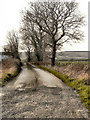
1
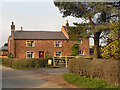
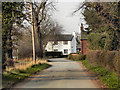
Prospect Lane, Rixton.
Prospect Lane leads to Prospect Farm ( in SJ6791). Taken from SJ682912.
Image: © Keith Williamson
Taken: 3 Aug 2005
0.13 miles
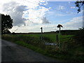
2

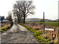
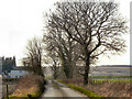
Moss Side, Rixton
The water bodies here have accumulated as a result of extraction of clay (as at Rixton Clay Pits nearby). A major use of land in this area is landfill tipping. A tip is visible on the horizon. Taken from SJ682915
Image: © Keith Williamson
Taken: 3 Aug 2005
0.13 miles