IMAGES TAKEN NEAR TO
Manchester Road, WARRINGTON, WA3 6DU
Introduction
This page details the photographs taken nearby to Manchester Road, WA3 6DU by members of the Geograph project.
The Geograph project started in 2005 with the aim of publishing, organising and preserving representative images for every square kilometre of Great Britain, Ireland and the Isle of Man.

There are currently over 7.5m images from over14,400 individuals and you can help contribute to the project by visiting https://www.geograph.org.uk
Image Map
Images are licensed for reuse under creativecommons.org/licenses/by-sa/2.0
Notes
- Clicking on the map will re-center to the selected point.
- The higher the marker number, the further away the image location is from the centre of the postcode.
Image Listing (10 Images Found)
Images are licensed for reuse under creativecommons.org/licenses/by-sa/2.0
Image
Details
Distance
2
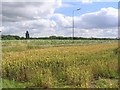
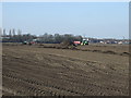
Wheat field
This shot is a view across two fields, the near field is of wheat and the field behind is potatoes. The fields are divided by the A57 as it passes from J21 of the M6 towards Rixton. The photo was taken from SJ667893 looking SW towards the M6, some the overhead signs can be seen in the distance.
Image: © Dave Smethurst
Taken: 20 Jul 2005
0.10 miles
4
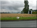
Rixton, milestone
Rather battered milestone near Holly Bush Lane on the A57. Distinctive shape: level top, plan roughly triangular, with curving front edges, erected by the Warrington & Lower Irlam Trust; legend reads: TO/WARRINGTON/4/(MILES)//TO/MANCHESTER/14/(MILES). For a better preserved example, see Image
Image: © Mike Faherty
Taken: 24 Aug 2008
0.11 miles
5
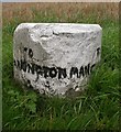
Old Milestone by the A57, Manchester Road, Rixton
Carved stone post by the A57, in parish of Rixton with Glazebrook (Warrington District), Manchester Road, Rixton; 100m West of Holly Bush Lane opposite No. 24, on the verge, on South side of road. Warrington flat top, erected by the Warrington & Lower Irlam turnpike trust in the 19th century.
Inscription reads:-
: TO / WARRINGTON / 4 : : TO / MANCHESTER / 14 :
Grade II listed.
List Entry Number: 1392447 https://historicengland.org.uk/listing/the-list/list-entry/1392447
Milestone Society National ID: LA_WAMA04
Image: © M Faherty
Taken: 24 Aug 2008
0.11 miles
9
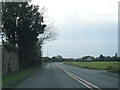
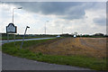
Manchester Road (A57)
Manchester Road, approaching Holly Bush Lane.
Image: © David Dixon
Taken: 18 Apr 2011
0.15 miles
10
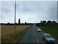
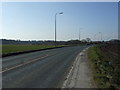
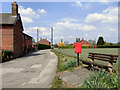
Manchester Road near Brookside Farm
Image: © Raymond Knapman
Taken: 5 Aug 2014
0.15 miles