IMAGES TAKEN NEAR TO
Warrington Road, WARRINGTON, WA3 6BQ
Introduction
This page details the photographs taken nearby to Warrington Road, WA3 6BQ by members of the Geograph project.
The Geograph project started in 2005 with the aim of publishing, organising and preserving representative images for every square kilometre of Great Britain, Ireland and the Isle of Man.

There are currently over 7.5m images from over14,400 individuals and you can help contribute to the project by visiting https://www.geograph.org.uk
Image Map
Images are licensed for reuse under creativecommons.org/licenses/by-sa/2.0
Notes
- Clicking on the map will re-center to the selected point.
- The higher the marker number, the further away the image location is from the centre of the postcode.
Image Listing (6 Images Found)
Images are licensed for reuse under creativecommons.org/licenses/by-sa/2.0
Image
Details
Distance
3
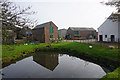
Bates Farm
A mixed farm with both arable and livestock.
Image: © Bill Boaden
Taken: 31 Oct 2016
0.15 miles
4
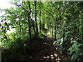
Footpath by a wood
Running alongside a wood on the right and a hayfield on the left.
Image: © philandju
Taken: 5 Jul 2012
0.21 miles
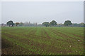
5

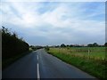
Track to Bates Farm
I presume the fields each side are growing winter wheat.
Image: © Bill Boaden
Taken: 31 Oct 2016
0.21 miles
6
A planted field by Glaziers Lane
A couple of houses of the village of Wigshaw can be seen, while the trees ahead obscure Culcheth.
Image: © Bill Boaden
Taken: 31 Oct 2016
0.22 miles