IMAGES TAKEN NEAR TO
Haydock Street, WARRINGTON, WA2 7UW
Introduction
This page details the photographs taken nearby to Haydock Street, WA2 7UW by members of the Geograph project.
The Geograph project started in 2005 with the aim of publishing, organising and preserving representative images for every square kilometre of Great Britain, Ireland and the Isle of Man.

There are currently over 7.5m images from over14,400 individuals and you can help contribute to the project by visiting https://www.geograph.org.uk
Image Map
Images are licensed for reuse under creativecommons.org/licenses/by-sa/2.0
Notes
- Clicking on the map will re-center to the selected point.
- The higher the marker number, the further away the image location is from the centre of the postcode.
Image Listing (99 Images Found)
Images are licensed for reuse under creativecommons.org/licenses/by-sa/2.0
Image
Details
Distance
1
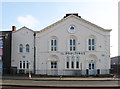
Warrington - The Boultings
On Winwick Street.
Image: © Dave Bevis
Taken: 18 Feb 2013
0.06 miles
4
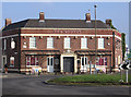
Warrington - The Rodney
On Winwick Road. For an alternative view, please see Image
Image: © Dave Bevis
Taken: 18 Feb 2013
0.08 miles
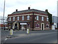
5
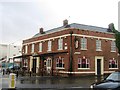
The Rodney, Warrington
A public house
Image: © Alex McGregor
Taken: 18 Oct 2011
0.08 miles
6
Warrington - Tannery Court
On Winwick Street.
Image: © Dave Bevis
Taken: 18 Feb 2013
0.09 miles
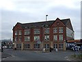
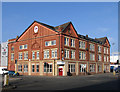
7

Grand Central apartments, Warrington
The "Grand Central" apartments in Warrington are in a converted railway warehouse close to Warrington Central station. The railway through Warrington Central was built by the Cheshire Lines Committee, whose name is prominent in the stonework.
Image: © Malc McDonald
Taken: 8 Oct 2011
0.09 miles
8
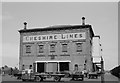
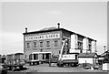
Warrington (Cheshire Lines) Goods warehouse ? 1964
Built in similar style to the company's warehouse at Brunswick Dock, Liverpool. In the foreground is one of the classic Scammell Scarab 'mechanical horse' type lorries, a type much favoured by railway companies. They were extremely manoeuvrable in tight spaces and could be readily attached to and detached from their trailers, several more of which are also visible. The building survives, having been converted to apartments, and is Listed Grade II. https://www.geograph.org.uk/photo/2639102
Image: © Alan Murray-Rust
Taken: 29 Jun 1964
0.09 miles
9
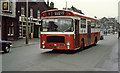
All Change on Winwick Street
Warrington Corporation number 95, a Bristol RE with East Lanc's bodywork passes the Kings Head public house near Warrington Station on route 1 for Westy.
This street has changed considerably. All the buildings from the exhaust centre next to the pub, as far as the large building beyond the Esso sign, have been demolished. The large building marks the junction with Tanners Lane. A whole road (Foundry Street), which used to connect with Winwick road roughly where the pedestrians can be seen on the central island, has also disappeared under the developers bulldozers.
Image: © Martin Addison
Taken: 8 Mar 1980
0.10 miles
10
Warrington (Cheshire Lines) Goods warehouse ? 1964
Built in similar style to the company's warehouse at Brunswick Dock, Liverpool. Note the typical British Railways road haulage vehicles. The building survives, having been converted to apartments, and is Listed Grade II. https://www.geograph.org.uk/photo/3340757 shows the lettering on the side of the building to better effect following removal of the timber hoist enclosures.
Image: © Alan Murray-Rust
Taken: 29 Jun 1964
0.10 miles