IMAGES TAKEN NEAR TO
Winwick Street, WARRINGTON, WA2 7TT
Introduction
This page details the photographs taken nearby to Winwick Street, WA2 7TT by members of the Geograph project.
The Geograph project started in 2005 with the aim of publishing, organising and preserving representative images for every square kilometre of Great Britain, Ireland and the Isle of Man.

There are currently over 7.5m images from over14,400 individuals and you can help contribute to the project by visiting https://www.geograph.org.uk
Image Map
Images are licensed for reuse under creativecommons.org/licenses/by-sa/2.0
Notes
- Clicking on the map will re-center to the selected point.
- The higher the marker number, the further away the image location is from the centre of the postcode.
Image Listing (143 Images Found)
Images are licensed for reuse under creativecommons.org/licenses/by-sa/2.0
Image
Details
Distance
1
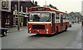
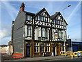
All Change on Winwick Street
Warrington Corporation number 95, a Bristol RE with East Lanc's bodywork passes the Kings Head public house near Warrington Station on route 1 for Westy.
This street has changed considerably. All the buildings from the exhaust centre next to the pub, as far as the large building beyond the Esso sign, have been demolished. The large building marks the junction with Tanners Lane. A whole road (Foundry Street), which used to connect with Winwick road roughly where the pedestrians can be seen on the central island, has also disappeared under the developers bulldozers.
Image: © Martin Addison
Taken: 8 Mar 1980
0.02 miles
2
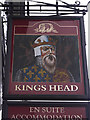
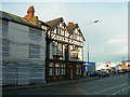
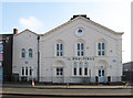
Kings Head, Winwick Street
The pub sign depicts the head of King Edward III.
Image: © michael ely
Taken: 16 Dec 2008
0.02 miles
3
Kings Head, Winwick Street
Located almost opposite Warrington Central railway station. Winwick Street looks rather down at heel but nearby parts of the town have seen a lot of regeneration over recent years.
Image: © michael ely
Taken: 16 Dec 2008
0.03 miles
4
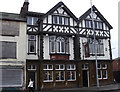
The Kings Head, Warrington
The Kings Head pub in Warrington.
Image: © Malc McDonald
Taken: 8 Oct 2011
0.03 miles
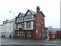
6
The Kings Head Pub
A slightly lonely looking Kings Head pub on Winwick Street as more and more of the surrounding properties have been demolished (for development of the site it is assumed)
Image: © Mike Lyne
Taken: 26 Jan 2012
0.03 miles
7
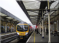
Warrington Central station
The next train to arrive at platform one will be the 14:44 Trans-Pennine Express to Scarborough.
Image: © michael ely
Taken: 16 Dec 2008
0.05 miles
9
Warrington - The Boultings
On Winwick Street.
Image: © Dave Bevis
Taken: 18 Feb 2013
0.05 miles
10
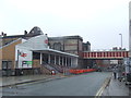
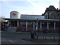
Warrington Central Station
Warrington Central is one of two railway stations serving the town of Warrington. Central is on a railway line running east-west through the town, linking Manchester with Liverpool, while the other station (Bank Quay) is on the West Coast Main Line which runs north-south.
The original station entrance and ticket office were in the buildings above street level, which were accessed from a forecourt off the street.
Image: © Malc McDonald
Taken: 8 Oct 2011
0.06 miles