IMAGES TAKEN NEAR TO
Newcombe Avenue, WARRINGTON, WA2 7TA
Introduction
This page details the photographs taken nearby to Newcombe Avenue, WA2 7TA by members of the Geograph project.
The Geograph project started in 2005 with the aim of publishing, organising and preserving representative images for every square kilometre of Great Britain, Ireland and the Isle of Man.

There are currently over 7.5m images from over14,400 individuals and you can help contribute to the project by visiting https://www.geograph.org.uk
Image Map
Images are licensed for reuse under creativecommons.org/licenses/by-sa/2.0
Notes
- Clicking on the map will re-center to the selected point.
- The higher the marker number, the further away the image location is from the centre of the postcode.
Image Listing (9 Images Found)
Images are licensed for reuse under creativecommons.org/licenses/by-sa/2.0
Image
Details
Distance

6
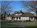
Rylands Recreation Club
Rylands Recreation Club, off Gorsey Lane. Many very active sports clubs are located here, including rugby, football, tennis, as well as the bar and other indoor pursuits.
Image: © Mike Lyne
Taken: 2 Feb 2012
0.22 miles
7
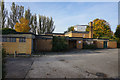
James Phoenix House
A former Council car home which was opened in 1974 but is now likely to be demolished.
Image: © Bill Boaden
Taken: 31 Oct 2016
0.24 miles