IMAGES TAKEN NEAR TO
Fallowfield Grove, WARRINGTON, WA2 0QQ
Introduction
This page details the photographs taken nearby to Fallowfield Grove, WA2 0QQ by members of the Geograph project.
The Geograph project started in 2005 with the aim of publishing, organising and preserving representative images for every square kilometre of Great Britain, Ireland and the Isle of Man.

There are currently over 7.5m images from over14,400 individuals and you can help contribute to the project by visiting https://www.geograph.org.uk
Image Map
Images are licensed for reuse under creativecommons.org/licenses/by-sa/2.0
Notes
- Clicking on the map will re-center to the selected point.
- The higher the marker number, the further away the image location is from the centre of the postcode.
Image Listing (5 Images Found)
Images are licensed for reuse under creativecommons.org/licenses/by-sa/2.0
Image
Details
Distance
1
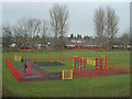
Children's Play Area, Longbarn Pool Park
The (rather bright) play area in the Longbarn Pool Park
Image: © Mike Lyne
Taken: 7 Feb 2012
0.11 miles
3
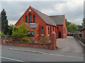
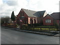
Risley Independent Methodist Church
The Methodist church on Fearnhead Lane.
Image: © David Dixon
Taken: 24 Jul 2012
0.24 miles
4
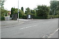
Entrance to Padgate College
This is the entrance to Padgate College along Fearnhead Lane, Padgate, Warrington.
Image: © andy
Taken: 14 Jul 2005
0.25 miles
5
Fearnhead, Methodist church
Technically, Risley Independent Methodist Church, relocated from nearby Warrington Road. For older pictures, see http://risleyimchurch.fotopic.net/list_collections.php
Image: © Mike Faherty
Taken: 23 Jan 2009
0.25 miles