IMAGES TAKEN NEAR TO
Broom Lane, KNUTSFORD, WA16 9PR
Introduction
This page details the photographs taken nearby to Broom Lane, WA16 9PR by members of the Geograph project.
The Geograph project started in 2005 with the aim of publishing, organising and preserving representative images for every square kilometre of Great Britain, Ireland and the Isle of Man.

There are currently over 7.5m images from over14,400 individuals and you can help contribute to the project by visiting https://www.geograph.org.uk
Image Map
Images are licensed for reuse under creativecommons.org/licenses/by-sa/2.0
Notes
- Clicking on the map will re-center to the selected point.
- The higher the marker number, the further away the image location is from the centre of the postcode.
Image Listing (15 Images Found)
Images are licensed for reuse under creativecommons.org/licenses/by-sa/2.0
Image
Details
Distance
1
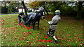
WW I display at Smithy Green, Lower Peover
Image: © Colin Park
Taken: 4 Nov 2018
0.02 miles
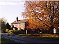
2
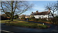
Old cottages at Smithy Green, Lower Peover
Image: © Colin Park
Taken: 7 Dec 2016
0.05 miles
3
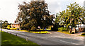
Smithy Green
The hamlet of Smithy Green near Lower Peover.
Image: © Peter McDermott
Taken: 13 Sep 2014
0.05 miles
5
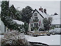
The Bells of Peover
The entrance of the pub leads straight into the church. The pub is named after a family that ran it and has nothing to do with the church bells. Sadly, another pub lost to a national chain but worth a visit.
Image: © John Naisbitt
Taken: 28 Nov 2005
0.06 miles
6
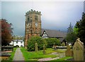
Church at Lower Peover
The body of the church with its black and white timbering dates from the 14th century. The Perpendicular stone tower is a later addition, built in 1582.
Image: © Stephen Nunney
Taken: Unknown
0.06 miles
7
Tree wrapped in plastic
I don't know what is going on here. Perhaps it is going to be turned into a sculpture.
Image: © Bikeboy
Taken: 16 Apr 2015
0.12 miles
8
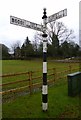
Old Direction Sign - Signpost by the B5081, Middlewich Road
Pawn finial - 2 arms; Cheshire New CCC octagonal by the B5081, in parish of Peover Inferior (Macclesfield District), junction of Middlewich Road with Plumley Moor Road, on verge, East side of road.
Surveyed
Milestone Society National ID: CH_SJ7474
Image: © Milestone Society
Taken: Unknown
0.14 miles
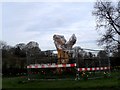
9
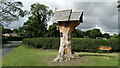
Lower Peover - Tree of Imagination
Constructed in 2015 from the trunk of an old tree that once stood on this rural road junction.
Image: © Colin Park
Taken: 13 Aug 2016
0.14 miles
10
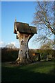
Tree of Imagination, Barrows Brow, Lower Peover
Image: © Ian S
Taken: 5 Jan 2022
0.14 miles