IMAGES TAKEN NEAR TO
Middlewich Road, KNUTSFORD, WA16 9JR
Introduction
This page details the photographs taken nearby to Middlewich Road, WA16 9JR by members of the Geograph project.
The Geograph project started in 2005 with the aim of publishing, organising and preserving representative images for every square kilometre of Great Britain, Ireland and the Isle of Man.

There are currently over 7.5m images from over14,400 individuals and you can help contribute to the project by visiting https://www.geograph.org.uk
Image Map
Images are licensed for reuse under creativecommons.org/licenses/by-sa/2.0
Notes
- Clicking on the map will re-center to the selected point.
- The higher the marker number, the further away the image location is from the centre of the postcode.
Image Listing (25 Images Found)
Images are licensed for reuse under creativecommons.org/licenses/by-sa/2.0
Image
Details
Distance
1
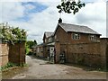
Woodside Farm, Allostock
The farm's name no longer describes its location: nearly all of the original Shakerley Wood was developed first for sand quarrying and later as fishing lakes.
Image: © Stephen Craven
Taken: 26 Jun 2021
0.01 miles
2
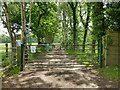
Gate across a track by Woodside Farm
The gate marks the end of the public road. Beyond it is access only for fishermen (PAAS stands for the Prince Albert Angling Society) although there is a public right of way on foot via the kissing gate to the left.
Image: © Stephen Craven
Taken: 26 Jun 2021
0.03 miles

4
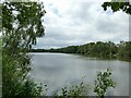
Dove Mere
One of three lakes formed from old sand pits either side of the M6 near Allostock. The others are Shakerley Mere to the west of the motorway, and Sand Mere south-east of this one. Dove and Sand Meres are owned (or at least used) by the Prince Albert Angling Society.
Image: © Stephen Craven
Taken: 26 Jun 2021
0.10 miles
5
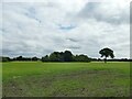
Farmland near Allostock
Typical of mid-Cheshire.
Image: © Stephen Craven
Taken: 26 Jun 2021
0.14 miles
6

Allostock : M6 Motorway
The M6 Motorway between Junction 18 and Junction 19.
Image: © Lewis Clarke
Taken: 23 Sep 2019
0.17 miles
7
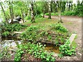
Inflow, Shakerley Mere
Shakerley Mere was once a quarry, where sand was excavated to make coloured glass. When production ended in the early 1960s, the quarry filled with water and became a mere. It is now a popular leisure and wildlife site, run by the council.
Image: © Christine Johnstone
Taken: 13 May 2012
0.18 miles
8
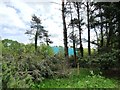
Eastern boundary, Shakerley Mere
The blue 'box' is a northbound lorry on the M6. Shakerley Mere was once a quarry, where sand was excavated to make coloured glass. When production ended in the early 1960s, the quarry filled with water and became a mere. It is now a popular leisure and wildlife site, run by the council.
Image: © Christine Johnstone
Taken: 13 May 2012
0.18 miles
9
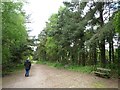
Anti-clockwise walker, Shakerley Mere
Shakerley Mere was once a quarry, where sand was excavated to make coloured glass. When production ended in the early 1960s, the quarry filled with water and became a mere. It is now a popular leisure and wildlife site, run by the council.
Image: © Christine Johnstone
Taken: 13 May 2012
0.18 miles
10
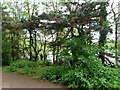
Anglers' day camp, Shakerley Mere
Shakerley Mere was once a quarry, where sand was excavated to make coloured glass. When production ended in the early 1960s, the quarry filled with water and became a mere. It is now a popular leisure and wildlife site, run by the council. The angling is managed by the Lymm Angling Club.
Image: © Christine Johnstone
Taken: 13 May 2012
0.18 miles