IMAGES TAKEN NEAR TO
Church Lane, KNUTSFORD, WA16 7QX
Introduction
This page details the photographs taken nearby to Church Lane, WA16 7QX by members of the Geograph project.
The Geograph project started in 2005 with the aim of publishing, organising and preserving representative images for every square kilometre of Great Britain, Ireland and the Isle of Man.

There are currently over 7.5m images from over14,400 individuals and you can help contribute to the project by visiting https://www.geograph.org.uk
Image Map
Images are licensed for reuse under creativecommons.org/licenses/by-sa/2.0
Notes
- Clicking on the map will re-center to the selected point.
- The higher the marker number, the further away the image location is from the centre of the postcode.
Image Listing (10 Images Found)
Images are licensed for reuse under creativecommons.org/licenses/by-sa/2.0
Image
Details
Distance
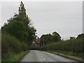

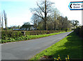
3
Lady Lane
Lady Lane originally ran from the junction of Church Lane and Hobcroft Lane at SJ790806 to the junction of Wood Lane and Ostlers Lane at SJ795817. The latter junction and the northern end of Lady Lane was lost when Manchester Airport's second runway was constructed.
Image: © Peter Whatley
Taken: 17 Sep 2009
0.14 miles
4
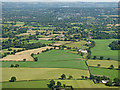
Farmland near Kimbles from the air
Seen shortly after take-off from runway 23L at Manchester Airport.
Image: © Thomas Nugent
Taken: 17 Jul 2017
0.15 miles
5
Mobberley from the air
Seen just after take-off from Manchester Airport.
Image: © Thomas Nugent
Taken: 6 Jul 2020
0.16 miles
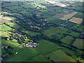
6
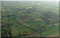
Kimbles from the air
Shortly after takeoff from Manchester Airport.
Image: © Thomas Nugent
Taken: 10 Nov 2014
0.19 miles
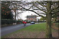
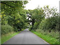
9
Davenport Lane - south west, Mobberley
Image: © Anthony O'Neil
Taken: 6 Apr 2011
0.20 miles
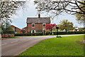
10
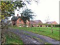
Sunny Bank Farm
Looks idyllic doesn't it? Except it now has the extension to the runway at Manchester International Airport in the back garden. Compare the modern OS map to the one from the 1940's.
Image: © Roger May
Taken: 15 Nov 2005
0.25 miles