IMAGES TAKEN NEAR TO
Swineyard Lane, KNUTSFORD, WA16 0RX
Introduction
This page details the photographs taken nearby to Swineyard Lane, WA16 0RX by members of the Geograph project.
The Geograph project started in 2005 with the aim of publishing, organising and preserving representative images for every square kilometre of Great Britain, Ireland and the Isle of Man.

There are currently over 7.5m images from over14,400 individuals and you can help contribute to the project by visiting https://www.geograph.org.uk
Image Map
Images are licensed for reuse under creativecommons.org/licenses/by-sa/2.0
Notes
- Clicking on the map will re-center to the selected point.
- The higher the marker number, the further away the image location is from the centre of the postcode.
Image Listing (10 Images Found)
Images are licensed for reuse under creativecommons.org/licenses/by-sa/2.0
Image
Details
Distance
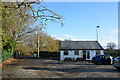
1
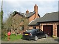
Wheelwright's Cottage
Wheelwright's Cottage, Swineyard Lane, High Legh.
Image: © Mike Harris
Taken: 24 Mar 2007
0.13 miles
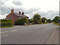
3
Tishon House
Tishon House on the A50.
Image: © Peter McDermott
Taken: 29 Nov 2014
0.16 miles
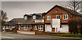
6
High Legh Tennis Club
Car park and clubhouse. The club's three courts are to the right of this shot.
Image: © Trevor Harris
Taken: 27 Nov 2021
0.21 miles
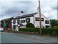
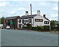
8
The Bears Paw Inn
Michelin may have a bit of a start, but on the strength of one lunch here I’m tempted to start my own Good Food Guide.
Image: © Ian Greig
Taken: 5 Feb 2016
0.22 miles
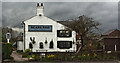
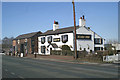
9
Pub/restaurant at Sworton Heath, Cheshire
Image: © Anthony O'Neil
Taken: 24 Jun 2010
0.22 miles
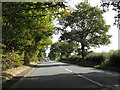
10
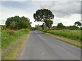
Place to pause
Popular stop on the A50 south of Warrington, near the M6/M56 junction
Image: © David Long
Taken: 4 Mar 2006
0.24 miles