IMAGES TAKEN NEAR TO
Winterbottom Lane, KNUTSFORD, WA16 0QG
Introduction
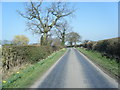
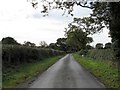
This page details the photographs taken nearby to Winterbottom Lane, WA16 0QG by members of the Geograph project.
The Geograph project started in 2005 with the aim of publishing, organising and preserving representative images for every square kilometre of Great Britain, Ireland and the Isle of Man.

There are currently over 7.5m images from over14,400 individuals and you can help contribute to the project by visiting https://www.geograph.org.uk
Image Map
Images are licensed for reuse under creativecommons.org/licenses/by-sa/2.0
Notes
- Clicking on the map will re-center to the selected point.
- The higher the marker number, the further away the image location is from the centre of the postcode.
Image Listing (7 Images Found)
Images are licensed for reuse under creativecommons.org/licenses/by-sa/2.0
Image
Details
Distance
1
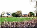
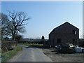
Daisy Bank Farm
Looking north up Winterbottom Lane at the rear of Daisy Bank Farm.
Image: © Roger May
Taken: 15 Nov 2005
0.01 miles
6
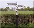
Old Direction Sign - Signpost by Hoo Green Lane, Knutsford Parish
Pawn finial - 4 arms; Cheshire CC post by the UC road (was A50), in parish of Knutsford (Macclesfield District), Winterbottom Lane junction with Hoo Green Lane at Goodiers Green.
To be surveyed
Milestone Society National ID: CH_SJ7182
Image: © Milestone Society
Taken: Unknown
0.17 miles
7
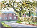
Goodiers Green Farm
This dilapidated building seems to have been a target for vandals on numerous occasions, judging from the number of broken windows it displays.
Image: © Roger May
Taken: 15 Nov 2005
0.18 miles