IMAGES TAKEN NEAR TO
Hale Road, ALTRINCHAM, WA15 8TF
Introduction
This page details the photographs taken nearby to Hale Road, WA15 8TF by members of the Geograph project.
The Geograph project started in 2005 with the aim of publishing, organising and preserving representative images for every square kilometre of Great Britain, Ireland and the Isle of Man.

There are currently over 7.5m images from over14,400 individuals and you can help contribute to the project by visiting https://www.geograph.org.uk
Image Map
Images are licensed for reuse under creativecommons.org/licenses/by-sa/2.0
Notes
- Clicking on the map will re-center to the selected point.
- The higher the marker number, the further away the image location is from the centre of the postcode.
Image Listing (85 Images Found)
Images are licensed for reuse under creativecommons.org/licenses/by-sa/2.0
Image
Details
Distance
1
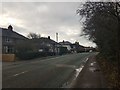
Along Hale Road
Looking along the A538 Hale Road.
Image: © DS Pugh
Taken: 21 Dec 2019
0.01 miles
2
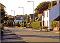
Afternoon sun in Hale Barns
Hale Road, looking towards the Village.
Image: © Anthony O'Neil
Taken: Unknown
0.02 miles
3
Hale Road, Hale Barns
Near Prospect Drive
Image: © Anthony O'Neil
Taken: Unknown
0.03 miles
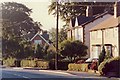
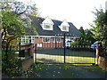
5
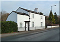
Cottage, Hale Road
One of the few remaining period buildings in Hale Barns. The majority of 18th and 19th century buildings (including those in the Village itself) have been demolished since the last War and replaced by modern residences and shops - a trend that started in the 1950s and continues to the present day. The greatest building boom has been only a mile away with the expansion of Manchester Airport and the establishment of new hotels, car parks and logistics companies which service it.
Image: © Anthony O'Neil
Taken: 1 Dec 2016
0.04 miles
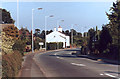
6
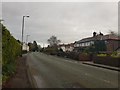
Hale Road near Rydal Drive
Looking along the A538.
Image: © DS Pugh
Taken: 21 Dec 2019
0.06 miles
7
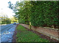
Hale Road, Hale Barns
Looking in the direction of the M56. To the right of the low brick wall there used to be two tennis courts in the gardens of Prospect House. This land was sold for building. Previously, the boundary wall of the gardens had been at the pavement edge, and about seven feet high. When nearby Prospect Drive was developed, this became a severe hazard for drivers trying to turn onto Hale Road without being able to see oncoming traffic.
Image: © Anthony O'Neil
Taken: 9 Nov 2013
0.06 miles
8
Prospect House, Hale Barns
This (relatively) modern property replaced the 19th century house of the same name which was the family home of Samuel Brooks, calico printer, banker and philanthropist who died in 1864 as one of the richest men in Manchester, with large landholdings both in Hale and in Whalley Range. He developed nearby Brooks' Drive (originally Brooks' Road) to connect Prospect House, via Davenport Green and Brooklands, to his properties in the city.
His son, William Cunliffe Brooks, became MP for Altrincham.
The present house used to have two adjacent tennis courts (then hidden behind a high brick boundary wall), an orchard, a parterre garden, and several acres of meadow at the back. All, except the garden, were sold off in the 1960s for building. The original surrounding wall was demolished to improve visibility for drivers on Hale Road. For a time, the house was home to the Hankinson family - local surveyors and developers - who built all the houses in nearby Prospect Drive.
Image: © Anthony O'Neil
Taken: 8 Nov 2013
0.06 miles
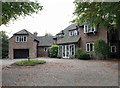
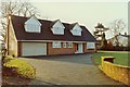
9
Detached residence on Hale Road
This house - briefly the home of a Manchester footballer - was built in the grounds of adjacent Prospect House. It occupies the former lawn tennis courts which lay parallel to Hale Road, behind the original eight foot, brick, perimeter wall. This was demolished to improve visibility and driver safety on the bend in Hale Road.
Image: © Anthony O'Neil
Taken: 9 Nov 2013
0.06 miles
10
Private residence, Hale Road
Former Hale Barns home of one of Manchester's footballers. Built over the tennis courts of adjacent Prospect House.
Image: © Anthony O'Neil
Taken: Unknown
0.06 miles