IMAGES TAKEN NEAR TO
Woodlands Parkway, ALTRINCHAM, WA15 6ST
Introduction
This page details the photographs taken nearby to Woodlands Parkway, WA15 6ST by members of the Geograph project.
The Geograph project started in 2005 with the aim of publishing, organising and preserving representative images for every square kilometre of Great Britain, Ireland and the Isle of Man.

There are currently over 7.5m images from over14,400 individuals and you can help contribute to the project by visiting https://www.geograph.org.uk
Image Map
Images are licensed for reuse under creativecommons.org/licenses/by-sa/2.0
Notes
- Clicking on the map will re-center to the selected point.
- The higher the marker number, the further away the image location is from the centre of the postcode.
Image Listing (23 Images Found)
Images are licensed for reuse under creativecommons.org/licenses/by-sa/2.0
Image
Details
Distance
1
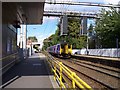
Trams at Navigation Road station, near Altrincham, Cheshire
Car no 1020 of Manchester Metrolink heads a two-car formation on a down service from Manchester to Altrincham. The method of working this station is very unusual: the left-hand track is used by trams in both directions, while the right-hand track, which is not electrified, is used for 'heavy rail' services, usually Manchester-Stockport-Altrincham-Chester
Image: © Dr Neil Clifton
Taken: 11 Jul 1992
0.06 miles
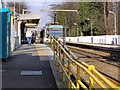
2
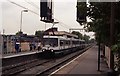
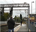
Navigation Road railway station
This station has a Metrolink platform on left and a Northern Rail platform on right of this view
Image: © Raymond Knapman
Taken: 4 Oct 2012
0.08 miles
3
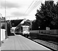
Navigation Road station
Car 1004 on its way to Altrincham
Image: © Dr Neil Clifton
Taken: 23 Aug 1993
0.08 miles
4
Navigation Road railway & Metrolink station, Greater Manchester
Opened in 1849 by the Manchester South Junction & Altrincham Railway on the line from Manchester London Road (now Piccadilly) to Altrincham, this station partially converted to Metrolink operation in 1992, which is why the electric overhead wires serve only the one platform that trams serve.
View north towards Timperley and Central Manchester
Image: © Nigel Thompson
Taken: 11 Dec 2010
0.08 miles
5
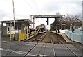
Navigation Road
At Navigation Road the Metrolink tram line from Altrincham operates on a single track as the right hand track still carries mainline trains.
Image: © Gerald England
Taken: 20 Sep 2011
0.08 miles
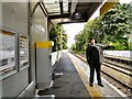
7
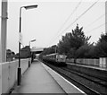
Be quick!
Navigation Road station level crossing: a man sprints for the train to Manchester. He's probably too occupied to notice the classic 1960s station design and typography.
Image: © Peter Whatley
Taken: 25 Jun 1988
0.08 miles
8
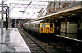
Altrincham station
In December 1991, heavy electric trains of Class 304 were still operating to Altrincham, although this would be their last month. A rainy 21 December sees 304 045 at Platform 1 with a service to Manchester.
Image: © Dr Neil Clifton
Taken: 21 Dec 1991
0.08 miles
9
Navigation Road
The last stop on the Metrolink tram line before Altrincham. On this section the tram lines run alongside the main railway line and so there is a platform on one side only creating a brief bottleneck. Immediately outside the station is a level crossing.
Image: © Gerald England
Taken: 20 Sep 2011
0.08 miles
10
Navigation Road station
In the days before Metrolink, a three-car Class 304 unit calls at Navigation Road with a Down service for Altrincham
Image: © Dr Neil Clifton
Taken: 1 Jun 1990
0.08 miles