IMAGES TAKEN NEAR TO
High Elm Road, ALTRINCHAM, WA15 0RN
Introduction
This page details the photographs taken nearby to High Elm Road, WA15 0RN by members of the Geograph project.
The Geograph project started in 2005 with the aim of publishing, organising and preserving representative images for every square kilometre of Great Britain, Ireland and the Isle of Man.

There are currently over 7.5m images from over14,400 individuals and you can help contribute to the project by visiting https://www.geograph.org.uk
Image Map
Images are licensed for reuse under creativecommons.org/licenses/by-sa/2.0
Notes
- Clicking on the map will re-center to the selected point.
- The higher the marker number, the further away the image location is from the centre of the postcode.
Image Listing (86 Images Found)
Images are licensed for reuse under creativecommons.org/licenses/by-sa/2.0
Image
Details
Distance
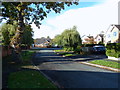
1
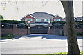
'The Greens', Hale Barns
A less than elegant - if expensive - replacement for 'Winmarith', the villa which stood here from pre-war times until beset by developers. This was the start of a trend which continues to the present day in Hale and Altrincham: the demolition of large, perfectly habitable homes, to make way for even larger but sometimes less elegant replacements. Doric columns (and gold-tipped, wrought-iron gates) have been a favourite appendage amongst local builders - for those that can afford them.
Image: © Anthony O'Neil
Taken: 9 Nov 2013
0.06 miles
2
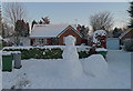
Winter arrives in Hale Barns
An unusual sight after 10 years of mild winters. Many young children may never before have been able to build a snowman.
Image: © Anthony O'Neil
Taken: 8 Jan 2010
0.06 miles
3
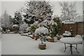
The morning after the night before - Hale Barns, Cheshire
No one expected to awake to this. The garden table registered six inches of virgin snow overnight.
Image: © Anthony O'Neil
Taken: 5 Jan 2010
0.06 miles
5
Hale Road, Hale Barns
Looking in the direction of Hale Barns village: the area in the distance was the site of Prospect House in the late 19th century. Opposite, at that time, was Easter Farm, and the road was then called Easter Road.
In the 20th century, the original house was demolished and replaced by a more modest building (which stands today). Most of the estate was sold for house building in the 1950s at which time there was a great extension of suburban development to the south west of Hale Barns.
Prospect House had been the country home of Sam Brooks - a banker and calico printer - who was said to be the richest man in the North West and left £6M in cash at his death (the modern day equivalent of around £1 billion).
On the land to the right of the photo, he built the beginnings of an ornamental carriageway intended to link up with his land holdings in south Manchester. This is the latter-day Brooks Drive, where none of the properties are less than £1M.
Image: © Anthony O'Neil
Taken: 30 Aug 2023
0.07 miles
6
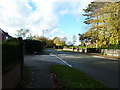
Junction of Hale Road with High Elm Road
Behind the trees, on the right, was the site of historic Easter Farm which was summarily demolished in the late 1930s after changes in UDC boundaries opened the way for housing development on adjacent Brooks' Drive. Hale Road - on 19th century, and earlier, maps - was called Easter Lane because it led to the farm from Hale and Altrincham.
Image: © Anthony O'Neil
Taken: 10 Nov 2013
0.07 miles
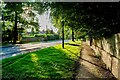
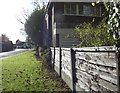
7
Pavement beside Hale Road
Looking along the pavement along the north side of Hale Road.
Image: © DS Pugh
Taken: 21 Dec 2019
0.07 miles
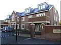
8
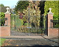
Ring before entering!
Not your average driveway, but gates like these are not uncommon in Hale and Bowdon. These belong to 'Brookdale' on Hale Road.
Image: © Anthony O'Neil
Taken: 10 Nov 2013
0.07 miles
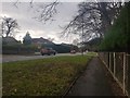
9
Boundary of Winmarith Drive, Hale Barns
At the junction with Hale Road. The 1910 map of Hale shows a farm track and public footpath here which ran directly across meadows and farmland to Warburton Green (and nearby Tanyard Farm) where there was a small hamlet and shop. The fence in the photo marks its edge and direction. In the 1950s, it was still the side access to a paddock at the back of nearby Prospect House. The construction of Winmarith Drive and adjacent roads completely obliterated this rural sector of Hale Barns.
Image: © Anthony O'Neil
Taken: 9 Nov 2013
0.08 miles