IMAGES TAKEN NEAR TO
Sunbank Lane, ALTRINCHAM, WA15 0PX
Introduction
This page details the photographs taken nearby to Sunbank Lane, WA15 0PX by members of the Geograph project.
The Geograph project started in 2005 with the aim of publishing, organising and preserving representative images for every square kilometre of Great Britain, Ireland and the Isle of Man.

There are currently over 7.5m images from over14,400 individuals and you can help contribute to the project by visiting https://www.geograph.org.uk
Image Map
Images are licensed for reuse under creativecommons.org/licenses/by-sa/2.0
Notes
- Clicking on the map will re-center to the selected point.
- The higher the marker number, the further away the image location is from the centre of the postcode.
Image Listing (12 Images Found)
Images are licensed for reuse under creativecommons.org/licenses/by-sa/2.0
Image
Details
Distance
1
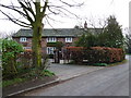
Converted cottages on Sunbank Lane, Ringway, Cheshire
Image: © Anthony O'Neil
Taken: 25 Mar 2011
0.02 miles
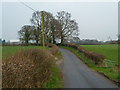
2

Sunbank Lane, Hale Barns
Not long ago, a rural backwater to the south east of Hale Barns village, but now overtaken by the ever-burgeoning spread of Manchester International Airport.
At its eastern end, it used to intersect the Wilmslow Road at the neighbouring parish of Ringway - the hamlet which gave its name to the original airport.
To the south-east of the road is Sunbank Wood - a once-quiet nature reserve - bordering the valley of the River Bollin.
Image: © Anthony O'Neil
Taken: 22 Mar 2020
0.08 miles
3
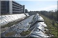
More than a garden pool!
This is a giant 'balancing pond', on Sunbank Lane: an artificial basin into which water drains from a building project. So constructed as to ensure that local watercourses are not overloaded during heavy rainfall, thereby preventing flooding of the site. Installed, in this case, at the new World Logistics Hub, near Manchester Airport.
Image: © Anthony O'Neil
Taken: 22 Mar 2020
0.10 miles
5
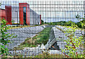
Drought?
Empty 'balancing pond': would normally fill with run-off from the surrounding construction site to form a water buffer and avoid the drainage system being overwhelmed at times of heavy rainfall: no such problem at present when there has been no significant precipitation for weeks on end.
Image: © Anthony O'Neil
Taken: 18 Aug 2022
0.11 miles
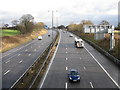
6
Modern office development
Adjacent to Manchester International Airport. Not many years ago, this was unspoiled farmland, with a nature reserve nearby, and a popular area for local walkers and cyclists. The ever-growing tentacles of Airport development have steadily eroded rural Ringway with office blocks, logistics companies and overflow car parks.
Image: © Anthony O'Neil
Taken: 18 Aug 2022
0.15 miles
7
Sunbank Lane, Ringway, Cheshire
Manchester Airport buildings in the distance.
Image: © Anthony O'Neil
Taken: 25 Mar 2011
0.16 miles
8
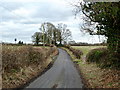
Sunbank Lane
Before the growth of Manchester International Airport and the M56, this was a fairly remote and quiet place: it will get even less so if plans, to develop nearby Oak Farm as another freight terminal for the airport, go ahead.
Image: © Anthony O'Neil
Taken: 6 Feb 2013
0.17 miles
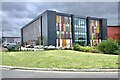
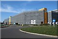
9
AMAZON Fulfilment Centre
Sunbank Lane, Hale Barns
Image: © Anthony O'Neil
Taken: 22 Mar 2020
0.18 miles
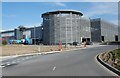
10
World Logistics Hub
Fringes of Manchester Airport
Image: © Anthony O'Neil
Taken: 22 Mar 2020
0.21 miles