IMAGES TAKEN NEAR TO
Lloyd Street, ALTRINCHAM, WA14 2SU
Introduction
This page details the photographs taken nearby to Lloyd Street, WA14 2SU by members of the Geograph project.
The Geograph project started in 2005 with the aim of publishing, organising and preserving representative images for every square kilometre of Great Britain, Ireland and the Isle of Man.

There are currently over 7.5m images from over14,400 individuals and you can help contribute to the project by visiting https://www.geograph.org.uk
Image Map
Images are licensed for reuse under creativecommons.org/licenses/by-sa/2.0
Notes
- Clicking on the map will re-center to the selected point.
- The higher the marker number, the further away the image location is from the centre of the postcode.
Image Listing (371 Images Found)
Images are licensed for reuse under creativecommons.org/licenses/by-sa/2.0
Image
Details
Distance
2
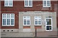
Altrincham Medical Practice
Now used as a medical centre, this building on Lloyd Street was formerly a telephone exchange.
Image: © Richard Sutcliffe
Taken: 18 Jun 2015
0.03 miles
3
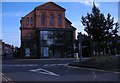
Altrincham Baptist Church
At first glance, with its glass entrance porch, and the notice saying 'Welcome to ABC', this building on Hale Road could almost be mistaken for a cinema! It is in fact the Altrincham Baptist Church.
Image: © Richard Sutcliffe
Taken: 18 Jun 2015
0.03 miles
4
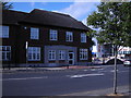
Lloyd House, Altrincham
Formerly a Pub
Image: © Anthony O'Neil
Taken: 4 Mar 2017
0.03 miles
6
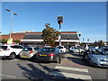
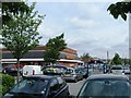
Part of Sainsbury's car park in Altrincham
A very crowded place on a Friday.
Image: © Jeremy Bolwell
Taken: 20 Sep 2019
0.04 miles
7
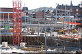
New building rises in Altrincham
This shows the structural steelwork in place for the new retail development opposite Sainsbury's. (The building was completed several years ago, as the current ordnance map indicates.)
Image: © Anthony O'Neil
Taken: 7 Apr 2003
0.05 miles
8
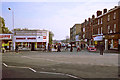
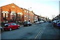
View of Lloyd Street, Altrincham
The distant trees mark the site of Sainsbury's, and the old narrow bridge over the railway was later replaced by a wide modern one to take late 20th century traffic. The photographer is standing at the bottom of The Downs, where passenger services from Manchester and Stretford used to terminate: first, horse drawn, then electric trams (from April 1907), then buses (also numbered 47 & 48). The vehicles used to turn around in this widely spaced road junction on Railway Street, where there once stood a cab stand.
Image: © Anthony O'Neil
Taken: Unknown
0.05 miles
9
Theatre, Oxford Road, Altrincham
The building on the left is the Altrincham Little Theatre. Known as the Club Theatre until 2012, it is one of the oldest still operating theatre groups in the UK, having been established in 1896 under its original name of St Margaret's Church Institute Amateur Dramatic Society.
Image: © Richard Sutcliffe
Taken: 27 Mar 2017
0.06 miles
10
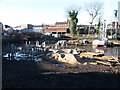
Redevelopment of Altrincham
This huge building site, to the east of Railway Street, will see the erection of shops, apartments and a fitness centre. (All now completed.) The trees and shrubbery, still visible behind the line of shops, are the only remaining traces of a hotel garden which was here in the 19th century. Future plans for the area include a new hospital.
Image: © Anthony O'Neil
Taken: 5 Dec 2002
0.06 miles