IMAGES TAKEN NEAR TO
St. Johns Road, ALTRINCHAM, WA14 2NA
Introduction
This page details the photographs taken nearby to St. Johns Road, WA14 2NA by members of the Geograph project.
The Geograph project started in 2005 with the aim of publishing, organising and preserving representative images for every square kilometre of Great Britain, Ireland and the Isle of Man.

There are currently over 7.5m images from over14,400 individuals and you can help contribute to the project by visiting https://www.geograph.org.uk
Image Map
Images are licensed for reuse under creativecommons.org/licenses/by-sa/2.0
Notes
- Clicking on the map will re-center to the selected point.
- The higher the marker number, the further away the image location is from the centre of the postcode.
Image Listing (193 Images Found)
Images are licensed for reuse under creativecommons.org/licenses/by-sa/2.0
Image
Details
Distance
1
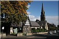
St Johns Medical Centre
A GP-run medical practice on St John's Road. Saint John the Evangelist Church is behind.
Image: © Richard Sutcliffe
Taken: 8 Oct 2016
0.02 miles
2
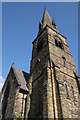
Saint John the Evangelist Church
The steeple viewed from beside St John's Road.
Image: © Richard Sutcliffe
Taken: 8 Oct 2016
0.04 miles
3
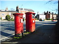
Pillar boxes at the junction of The Downs and Delamer Road
A George VI pillar box (postbox number WA14 26) [http://www.geograph.org.uk/photo/5328658], and a modern box for franked mail only (postbox number WA14 116) [http://www.geograph.org.uk/photo/5328666].
Image: © Richard Sutcliffe
Taken: 27 Mar 2017
0.04 miles
4
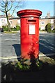
George VI pillar box
At the junction of The Downs and Delamer Road (postbox number WA14 26). It stands beside a modern box for franked mail only (postbox number WA14 116) [http://www.geograph.org.uk/photo/5328645].
Image: © Richard Sutcliffe
Taken: 27 Mar 2017
0.04 miles
5
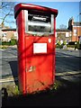
Postbox at the junction of The Downs and Delamer Road
A modern box for franked mail only (postbox number WA14 116). It stands beside a George VI pillar box (postbox number WA14 26) [http://www.geograph.org.uk/photo/5328645].
Image: © Richard Sutcliffe
Taken: 27 Mar 2017
0.04 miles
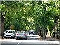
7
Looking up The Downs
The Downs carry on up to the right before becoming Higher Downs. Delamer Road bears round to the left.
Image: © Richard Sutcliffe
Taken: 27 Mar 2017
0.05 miles
8
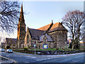
Parish Church of St John the Evangelist, Altrincham
St John's Church was built 1865-6. It is a Grade II listed building.
Image: © David Dixon
Taken: 14 Jan 2012
0.05 miles
9
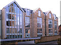
Luxury Apartments
St John's Road, Altrincham
Image: © Anthony O'Neil
Taken: 8 Feb 2023
0.05 miles
10
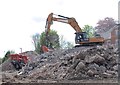
Digger at work
Site of planned new apartments in Altrincham
Image: © Anthony O'Neil
Taken: 2 May 2017
0.05 miles