IMAGES TAKEN NEAR TO
Birchbrook Road, LYMM, WA13 9RX
Introduction
This page details the photographs taken nearby to Birchbrook Road, WA13 9RX by members of the Geograph project.
The Geograph project started in 2005 with the aim of publishing, organising and preserving representative images for every square kilometre of Great Britain, Ireland and the Isle of Man.

There are currently over 7.5m images from over14,400 individuals and you can help contribute to the project by visiting https://www.geograph.org.uk
Image Map
Images are licensed for reuse under creativecommons.org/licenses/by-sa/2.0
Notes
- Clicking on the map will re-center to the selected point.
- The higher the marker number, the further away the image location is from the centre of the postcode.
Image Listing (42 Images Found)
Images are licensed for reuse under creativecommons.org/licenses/by-sa/2.0
Image
Details
Distance
1
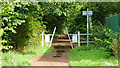
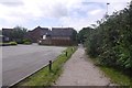
Trans Pennine Trail, Rushgreen
Entrance to Trans Pennine Trail from Chaise Meadow
Image: © Richard Cooke
Taken: 26 Aug 2012
0.05 miles
2
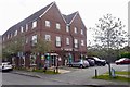
Co-op, Heatley
A new looking buildings with residential properties above the shop.
Image: © Richard Webb
Taken: 11 Aug 2019
0.05 miles
3
Trans Pennine Trail, Rushgreen
Short section of Trans Pennine Trail between Birch Brook Road (A6144) and Chaise Meadow
Image: © Richard Cooke
Taken: 26 Aug 2012
0.08 miles
4
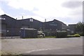
Elastomer Engineering
Manufacturer of rubber and cast polyurethane products.
Image: © Richard Webb
Taken: 11 Aug 2019
0.08 miles
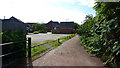
5
Trans Pennine Trail, Heatley
A rails to trails conversion, using the railway between Altrincham and Warrington which closed in 1985.
Image: © Richard Webb
Taken: 11 Aug 2019
0.09 miles
6
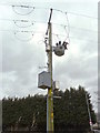
Local distribution pole
This installation provides electrical services to properties on the adjacent estate.
Image: © Anthony O'Neil
Taken: 22 Mar 2018
0.10 miles
7
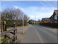
The site of a level crossing on the A6144 near Oughtrington
The old Warrington to Stockport Railway crossed the road on a skewed course here. This is now part of the Trans Pennine Trail
Image: © Raymond Knapman
Taken: 19 Mar 2014
0.11 miles
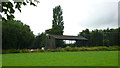

10
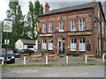
"The Railway" pub at Heatley
The railway from which the pub takes its name closed in the 1980s, and has been converted to a cycle track (part of the Trans-Pennine Trail). Alas, by 2009 the pub had closed. See: http://www.geograph.org.uk/photo/1337678
Image: © John Armitstead
Taken: 4 Jun 2005
0.13 miles