IMAGES TAKEN NEAR TO
Reddish Lane, LYMM, WA13 9PY
Introduction
This page details the photographs taken nearby to Reddish Lane, WA13 9PY by members of the Geograph project.
The Geograph project started in 2005 with the aim of publishing, organising and preserving representative images for every square kilometre of Great Britain, Ireland and the Isle of Man.

There are currently over 7.5m images from over14,400 individuals and you can help contribute to the project by visiting https://www.geograph.org.uk
Image Map
Images are licensed for reuse under creativecommons.org/licenses/by-sa/2.0
Notes
- Clicking on the map will re-center to the selected point.
- The higher the marker number, the further away the image location is from the centre of the postcode.
Image Listing (19 Images Found)
Images are licensed for reuse under creativecommons.org/licenses/by-sa/2.0
Image
Details
Distance
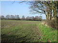
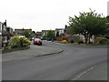
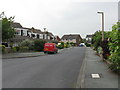
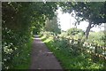
2
Reddish Lane heading north
Towards Reddish Hall.
Image: © JThomas
Taken: 2 Mar 2013
0.03 miles

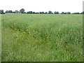
4
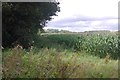
Forage maize, Reddish
Probably destined for an anaerobic digester, although the crop does still get used to generate methane in the traditional way, as a silage crop for cattle.
Image: © Richard Webb
Taken: 11 Aug 2019
0.04 miles
5
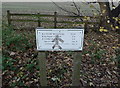
"Milestone" on the Trans Pennine Trail near Heatley
Image: © Anthony O'Neil
Taken: 11 Nov 2012
0.10 miles
7
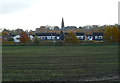
View of the Trans Pennine Trail from Reddish Lane
The Trail is defined by the long fence running in front of the houses. In the background is the spire of St. Peter's, Oughtrington.
Image: © Anthony O'Neil
Taken: 11 Nov 2012
0.13 miles
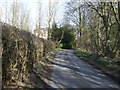
10
Warrington to Stockport trackbed
Now the Transpennine Trail. The line closed to passengers in 1962 and completely in 1985.
Image: © Richard Webb
Taken: 11 Aug 2019
0.16 miles