IMAGES TAKEN NEAR TO
Higher Lane, LYMM, WA13 0RL
Introduction
This page details the photographs taken nearby to Higher Lane, WA13 0RL by members of the Geograph project.
The Geograph project started in 2005 with the aim of publishing, organising and preserving representative images for every square kilometre of Great Britain, Ireland and the Isle of Man.

There are currently over 7.5m images from over14,400 individuals and you can help contribute to the project by visiting https://www.geograph.org.uk
Image Map
Images are licensed for reuse under creativecommons.org/licenses/by-sa/2.0
Notes
- Clicking on the map will re-center to the selected point.
- The higher the marker number, the further away the image location is from the centre of the postcode.
Image Listing (7 Images Found)
Images are licensed for reuse under creativecommons.org/licenses/by-sa/2.0
Image
Details
Distance
1

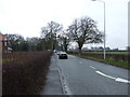
Road A56
This picture taken from SJ-70253-86075 shows the A56 running easterly towards Broomedge. The A56 is one of the major routes in this area.
Image: © Dave Smethurst
Taken: 3 Sep 2005
0.13 miles

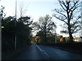
7
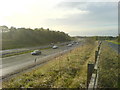
M56 between Broomedge and High Legh
The juxtaposition between the motorway and the quiet country lane at the right of the picture has, for a long while provided a place for me to contemplate what is and isn't important in life. I've often come here to think.
Image: © Steven
Taken: 6 Nov 2005
0.25 miles