IMAGES TAKEN NEAR TO
Bridgewater Street, LYMM, WA13 0AB
Introduction
This page details the photographs taken nearby to Bridgewater Street, WA13 0AB by members of the Geograph project.
The Geograph project started in 2005 with the aim of publishing, organising and preserving representative images for every square kilometre of Great Britain, Ireland and the Isle of Man.

There are currently over 7.5m images from over14,400 individuals and you can help contribute to the project by visiting https://www.geograph.org.uk
Image Map
Images are licensed for reuse under creativecommons.org/licenses/by-sa/2.0
Notes
- Clicking on the map will re-center to the selected point.
- The higher the marker number, the further away the image location is from the centre of the postcode.
Image Listing (134 Images Found)
Images are licensed for reuse under creativecommons.org/licenses/by-sa/2.0
Image
Details
Distance
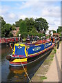
1
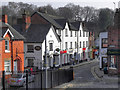
Lymm
Bridgewater Street, from the towpath on the Bridgewater Canal at Lymm.
Image: © David Dixon
Taken: 22 Mar 2012
0.01 miles
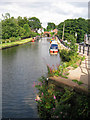
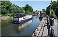
2
Boat Stage in Lymm
Viewed from the aqueduct on the Bridgewater Canal
Image: © Raymond Knapman
Taken: 19 Mar 2014
0.01 miles
3
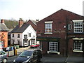
The Saddlers Arms Pub, Lymm
Bridgewater Street LYMM WA13 0AB close to The Bridgewater Canal
Image: © canalandriversidepubs co uk
Taken: 12 Apr 2010
0.02 miles
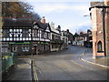
4
Lymm village centre
Central Lymm, at the junction of Eagle Brow and The Dingle, in Cheshire, England.
Image: © Steven Haslington
Taken: 27 Apr 2013
0.03 miles
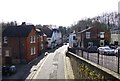
5
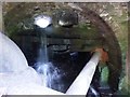
Sow Brook tunnel
Complicated triple channel of the Sow Brook passing under the A56 in the centre of Lymm.
Image: © Dave Dunford
Taken: 30 Jul 2015
0.03 miles
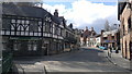
7
The Spread Eagle
Looking up Eagle Brow, 'The Spread Eagle' pub is on the left.
Image: © David Newton
Taken: 20 Nov 2009
0.03 miles
8
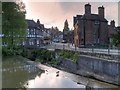
Lymm Dam at Lymm Bridge
Lymm Dam was built in 1824 when the turnpike road, which later became the present day A56, was created from Warrington to Stockport. Even in the early 19th century, there was concern over traffic congestion and local opposition prevented the road from passing through the centre of the village and so it was decided that the new road should cross what was then 'a pool and stream' in the valley below St Mary's Church.
In order to do this, an earth dam was constructed across the valley and, after its completion, the pool and stream below the church became the lake which is now known as Lymm Dam.
More information is available at http://lymm.com/about/history-of-lymm/lymm-dam-history - the history of Lymm Dam.
Image: © David Dixon
Taken: 15 May 2014
0.03 miles
10
The 'Lovely Day' passes through Lymm
The appropriately named "Lovely Day' passes through Lymm, travelling east along the Lymm Canal.
Image: © Matt Harrop
Taken: 26 May 2017
0.04 miles