IMAGES TAKEN NEAR TO
Castleton Drive, WARRINGTON, WA1 2GQ
Introduction
This page details the photographs taken nearby to Castleton Drive, WA1 2GQ by members of the Geograph project.
The Geograph project started in 2005 with the aim of publishing, organising and preserving representative images for every square kilometre of Great Britain, Ireland and the Isle of Man.

There are currently over 7.5m images from over14,400 individuals and you can help contribute to the project by visiting https://www.geograph.org.uk
Image Map
Images are licensed for reuse under creativecommons.org/licenses/by-sa/2.0
Notes
- Clicking on the map will re-center to the selected point.
- The higher the marker number, the further away the image location is from the centre of the postcode.
Image Listing (5 Images Found)
Images are licensed for reuse under creativecommons.org/licenses/by-sa/2.0
Image
Details
Distance
1
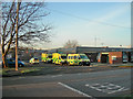
Ambulances waiting for the Shout
Ambulances and a Paramedic car ready to go at the Warrington Farrell Street Ambulance Station
Image: © Mike Lyne
Taken: 2 Feb 2012
0.15 miles

3
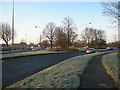
Kingsway Roundabout
A frosty Kingsway Roundabout on the A50 at the junction between Kingsway North, Kingsway South, and Farrell Street during the morning rush-hour.
Image: © Mike Lyne
Taken: 2 Feb 2012
0.23 miles