IMAGES TAKEN NEAR TO
Charnock Avenue, NEWTON-LE-WILLOWS, WA12 9HL
Introduction
This page details the photographs taken nearby to Charnock Avenue, WA12 9HL by members of the Geograph project.
The Geograph project started in 2005 with the aim of publishing, organising and preserving representative images for every square kilometre of Great Britain, Ireland and the Isle of Man.

There are currently over 7.5m images from over14,400 individuals and you can help contribute to the project by visiting https://www.geograph.org.uk
Image Map
Images are licensed for reuse under creativecommons.org/licenses/by-sa/2.0
Notes
- Clicking on the map will re-center to the selected point.
- The higher the marker number, the further away the image location is from the centre of the postcode.
Image Listing (13 Images Found)
Images are licensed for reuse under creativecommons.org/licenses/by-sa/2.0
Image
Details
Distance
1
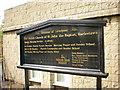
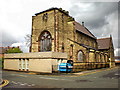
The Parish Church of St John the Baptist, Earlestown, Sign
Image: © Alexander P Kapp
Taken: 19 May 2009
0.22 miles
2
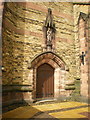
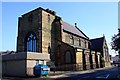
The Parish Church of St John the Baptist, Earlestown, Doorway
Image: © Alexander P Kapp
Taken: 19 May 2009
0.22 miles
3
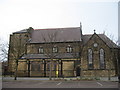
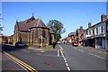
St John the Baptist
St John the Baptist in Earlestown is a large church but looks somewhat unbalanced probably due to the fact that the original plans had included a clock tower which had to be curtailed due to lack of funding. On August 4, 1875,the foundation stone was laid by Mrs. W J. Legh, wife of the Lord of the Manor, who had donated the land in Market Street. The new Church was consecrated on January 6, 1879.
Image: © Sue Adair
Taken: 24 Mar 2009
0.22 miles
4
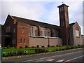
St. Patrick's R.C. Church, Common Road, Earlestown
This Church was erected in 1958 to replace the previous one erected in 1930.
Image: © Michael Heavey
Taken: 6 May 2007
0.22 miles
5
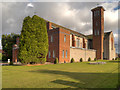
The Parish Church of St John the Baptist, Earlestown
Image: © Alexander P Kapp
Taken: 19 May 2009
0.23 miles
6
St John the Baptist Church in Earlestown
Image: © Steve Daniels
Taken: 15 Sep 2011
0.23 miles

9
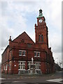
Earlestown Town Hall
Earlestown owes its development to early transport links such as the nearby Sankey Canal and the Liverpool to Manchester railway. Wagon building works were established and other industries followed, the Sankey Sugar works and the Vickers Engineering works. By the 1890s, the Earlestown area of Newton-le-Willows had outgrown the older part of the town and the market was moved to its current location in the market square and the Town Hall was erected.
Image: © Sue Adair
Taken: 24 Mar 2009
0.24 miles
10
Earlestown, St Patrick's RC Church
St Patrick's Roman Catholic Church in Earlestown is on Common Road, at the corner of Marian Avenue. The present church was built in 1958; it replaced an earlier church which had opened in July 1932 but was later destroyed by a fire.
Image: © David Dixon
Taken: 2 Feb 2013
0.25 miles