IMAGES TAKEN NEAR TO
Helmsley Close, NEWTON-LE-WILLOWS, WA12 9GW
Introduction
This page details the photographs taken nearby to Helmsley Close, WA12 9GW by members of the Geograph project.
The Geograph project started in 2005 with the aim of publishing, organising and preserving representative images for every square kilometre of Great Britain, Ireland and the Isle of Man.

There are currently over 7.5m images from over14,400 individuals and you can help contribute to the project by visiting https://www.geograph.org.uk
Image Map
Images are licensed for reuse under creativecommons.org/licenses/by-sa/2.0
Notes
- Clicking on the map will re-center to the selected point.
- The higher the marker number, the further away the image location is from the centre of the postcode.
Image Listing (25 Images Found)
Images are licensed for reuse under creativecommons.org/licenses/by-sa/2.0
Image
Details
Distance
1
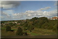
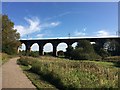
The view of the Sankey Valley from Stephenson's Viaduct, as seen from the 12.01 from Newton-le-Willows
The Sankey Brook runs leftwards from the centre. Parallel to it, and conveniently marked by a cyclist, runs the line of the infilled Sankey/ St Helens Canal. Stephenson had to build the massive viaduct, a 'first' in railway engineering, to accommodate the masts of the Mersey flats, the sailing vessels for which England's first industrial canal was built.
Image: © David Long
Taken: 8 Oct 2009
0.14 miles
2
Information board at site of Newton Lock
Image: © Raymond Knapman
Taken: 23 Jul 2010
0.15 miles
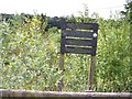
4
Signage at site of Newton Lock in Sankey Valley Park
Image: © Raymond Knapman
Taken: 23 Jul 2010
0.17 miles
5
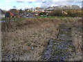
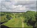
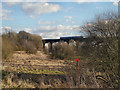
Newton Common Lock, Sankey Canal
The remains of Newton Common Lock are on the outskirts of Earlestown, situated about ½ a mile south of the A572 at a point where Wharf Road comes alongside the canal.
The lock was constructed in 1755 and rebuilt in 1885. The last barges passed here in 1919 and the lock was infilled in 1976 causing the lock to become completely buried but it has been partly uncovered by SCARS (the canal's restoration society) volunteers the chamber edges can now be seen.
A notice board stands over the lock (behind the lock in this photograph) giving information about the area. According to that notice, a project is being developed to excavate the area (Image]).
Image: © David Dixon
Taken: 2 Feb 2013
0.17 miles
6
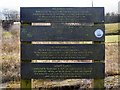
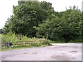
Newton Common Lock Information Board
Information board standing above the remains of Image] giving details about the lock, Sankey Viaduct and Sankey Canal.
Image: © David Dixon
Taken: 2 Feb 2013
0.18 miles
7
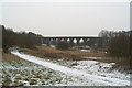
The Sankey Viaduct & the Sankey Canal
The snow enables us to see the line of England's first modern canal (1757 - so 250 years old this year) as it approaches the viaduct Stephenson had to build to take the world's first passenger railway across it. The high masts of the Mersey flats using the canal meant a clearance of 70 feet had to be allowed for beneath the railway.
Image: © David Long
Taken: 8 Feb 2007
0.18 miles
8
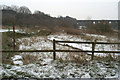
Remains of Newton Common Lock
The famous Sankey Viaduct forms the backdrop to this view of the section of the lock revealed through the work of the Sankey Canal Restoration Society. The canal was legally abandoned from this point northwards in 1931.
Image: © David Long
Taken: 8 Feb 2007
0.18 miles
10
Sankey Viaduct
A Northern Rail commuter train crosses Sankey Viaduct.
Constructed between 1828 and 1830 by George Stephenson for the Liverpool and Manchester Railway Company, the viaduct carried the World's first passenger railway which ran between Liverpool and Manchester. It has been designated by English Heritage as a Grade I listed building and is the earliest major railway viaduct in the world.
http://transportheritage.com/find-heritage-locations.html?sobi2Task=sobi2Details&sobi2Id=710 Transport Heritage Locations
Image: © David Dixon
Taken: 2 Feb 2013
0.19 miles