IMAGES TAKEN NEAR TO
Chain Lane, ST. HELENS, WA11 9QE
Introduction
This page details the photographs taken nearby to Chain Lane, WA11 9QE by members of the Geograph project.
The Geograph project started in 2005 with the aim of publishing, organising and preserving representative images for every square kilometre of Great Britain, Ireland and the Isle of Man.

There are currently over 7.5m images from over14,400 individuals and you can help contribute to the project by visiting https://www.geograph.org.uk
Image Map
Images are licensed for reuse under creativecommons.org/licenses/by-sa/2.0
Notes
- Clicking on the map will re-center to the selected point.
- The higher the marker number, the further away the image location is from the centre of the postcode.
Image Listing (41 Images Found)
Images are licensed for reuse under creativecommons.org/licenses/by-sa/2.0
Image
Details
Distance
3
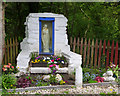
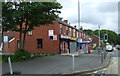
Shrine close to St Mary's Church, Blackbrook
Image: © Gary Rogers
Taken: 29 Apr 2017
0.15 miles
4
A58 Blackbrook By-Pass
A new road from the Ship Inn at Blackbrook to the A580 East Lancashire Road, to ease congestion on West End Road, Haydock. Due for completion Spring 2007.
Image: © Roy Prescott
Taken: 1 Aug 2006
0.15 miles
5
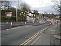
A58 Blackbrook By-Pass...Completed
Opened "on time and within budget" in March 2007. An award winning project which has succeeded in diverting large numbers of vehicles away from West End Road, as by-passes tend to do....good result for some people, not for others.
Image: © Roy Prescott
Taken: 18 Mar 2007
0.15 miles


9

Swan and cygnets
This swan has raised seven cygnets, they are now practically full sized
Image: © Ian Greig
Taken: 13 Aug 2019
0.18 miles
10
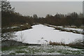
The Blackbrook Basin Terminus of the Sankey Canal
The Sankey Brook Navigation, commonly known as the Sankey Canal, was built between 1755 and 1757, making this the 250th Anniversary year of its opening.
The northern reaches of the canal were formally abandoned in 1931. This site, now the start of the Sankey Valley Linear Park, following the line of the canal to Widnes, would have been a hive of activity in the 18th & 19th Centuries. Coal was loaded here into Mersey flats to go to Liverpool, North Wales, Ireland, and the Lancashire coast, while copper ore was imported from Parys Mountain on Anglesey to a copper works nearby.
Image: © David Long
Taken: 8 Feb 2007
0.18 miles