IMAGES TAKEN NEAR TO
Church Road, ST. HELENS, WA11 8PX
Introduction
This page details the photographs taken nearby to Church Road, WA11 8PX by members of the Geograph project.
The Geograph project started in 2005 with the aim of publishing, organising and preserving representative images for every square kilometre of Great Britain, Ireland and the Isle of Man.

There are currently over 7.5m images from over14,400 individuals and you can help contribute to the project by visiting https://www.geograph.org.uk
Image Map
Images are licensed for reuse under creativecommons.org/licenses/by-sa/2.0
Notes
- Clicking on the map will re-center to the selected point.
- The higher the marker number, the further away the image location is from the centre of the postcode.
Image Listing (10 Images Found)
Images are licensed for reuse under creativecommons.org/licenses/by-sa/2.0
Image
Details
Distance
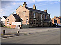
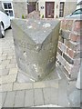
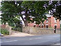
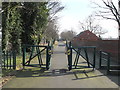
2
Old Milestone, Church Road, Rainford
Milestone on the UC road (was A570), in the parish of Rainford, St Helens District, Merseyside; Church Road, Rainford, against wall of No 116, South side of road. 19th century, erected by Lancashire County Council.
Inscription reads:- : St. HELENS / 4 / MILES : : ORMSKIRK / 7 / MILES : : RAINFORD :
Milestone Society National ID: LA_SSOK04.
Image: © Milestone Society
Taken: 18 May 2017
0.07 miles
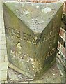
3
Old Milestone by the B5203, Church Road, Rainford Parish
Lancs CC stone triangle by the B5203 (was A570), in parish of Rainford (St Helens District), Church Road, Rainford, opposite junction with Rookery Lane against wall of No 116.
Surveyed
Milestone Society National ID: LA_SHOK04.
Image: © Milestone Society
Taken: Unknown
0.07 miles
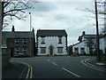
5
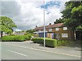
Rainford Police Station
On Church Road, now permanently closed: http://www.sthelensreporter.co.uk/news/crime/rainford-residents-to-have-say-on-police-station-plan-1-8357055
Image: © Mike Faherty
Taken: 31 Jul 2017
0.15 miles
6
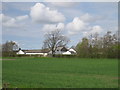
Pasture Lane Farm
Pasture Lane Farm from the Rainford By-Pass.
Image: © Sue Adair
Taken: 1 May 2013
0.16 miles
7
Footpath from Rookery Lane to Cross Pit Lane, Rainford
Image: © Gary Rogers
Taken: 26 Feb 2016
0.19 miles
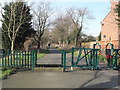
8
The Old Station House at Rookery
Station house at the Rookery Station halt site on Rainford Linear Park. A level crossing was located at this site.
Image: © Raymond Knapman
Taken: 29 Jun 2008
0.21 miles
9
Footpath from Rookery Lane to Sandwash Close, Rainford
Image: © Gary Rogers
Taken: 26 Feb 2016
0.21 miles
10
Rookery Drive, Rainford
BT Fibre optic broadband is here
Image: © Gary Rogers
Taken: 26 Feb 2016
0.24 miles