IMAGES TAKEN NEAR TO
Whalley Avenue, ST. HELENS, WA11 8HQ
Introduction
This page details the photographs taken nearby to Whalley Avenue, WA11 8HQ by members of the Geograph project.
The Geograph project started in 2005 with the aim of publishing, organising and preserving representative images for every square kilometre of Great Britain, Ireland and the Isle of Man.

There are currently over 7.5m images from over14,400 individuals and you can help contribute to the project by visiting https://www.geograph.org.uk
Image Map
Images are licensed for reuse under creativecommons.org/licenses/by-sa/2.0
Notes
- Clicking on the map will re-center to the selected point.
- The higher the marker number, the further away the image location is from the centre of the postcode.
Image Listing (39 Images Found)
Images are licensed for reuse under creativecommons.org/licenses/by-sa/2.0
Image
Details
Distance
1
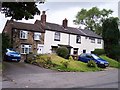
Cottages next Linear Park in Rainford
These cottages off Cross Pit Lane lie next to the site of a level crossing of the railway line from St Helens to Rainford Junction.
Image: © Raymond Knapman
Taken: 29 Jun 2008
0.02 miles
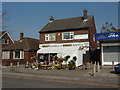
3
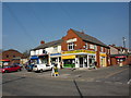
Village Larder, Church Road, Rainford
Image: © Alexander P Kapp
Taken: 28 Mar 2011
0.03 miles
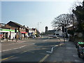
4
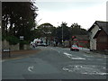
Cross Pit Lane, Rainford (B5205)
Heading east.
Image: © JThomas
Taken: 13 Sep 2014
0.04 miles
7
Wendy's Flowers, Church Road, Rainford
Image: © Alexander P Kapp
Taken: 28 Mar 2011
0.05 miles
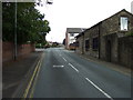
8
Rainford, former Sunday School
On Ormskirk Road, with a plaque dated 1825. Now residential.
Image: © Mike Faherty
Taken: 31 Jul 2017
0.05 miles

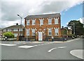
10
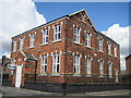
The Old Schoolhouse
The old Schoolhouse at the junction of Cross Pit Lane and Ormskirk Road, now converted to residential use. The plaque reads " This Land was given by the Right Honourable the Earl of Derby for a day or Sunday School for Ever - 1825".
Image: © Sue Adair
Taken: 1 May 2013
0.05 miles