IMAGES TAKEN NEAR TO
Crossdale Way, ST. HELENS, WA11 7BD
Introduction
This page details the photographs taken nearby to Crossdale Way, WA11 7BD by members of the Geograph project.
The Geograph project started in 2005 with the aim of publishing, organising and preserving representative images for every square kilometre of Great Britain, Ireland and the Isle of Man.

There are currently over 7.5m images from over14,400 individuals and you can help contribute to the project by visiting https://www.geograph.org.uk
Image Map
Images are licensed for reuse under creativecommons.org/licenses/by-sa/2.0
Notes
- Clicking on the map will re-center to the selected point.
- The higher the marker number, the further away the image location is from the centre of the postcode.
Image Listing (10 Images Found)
Images are licensed for reuse under creativecommons.org/licenses/by-sa/2.0
Image
Details
Distance
2
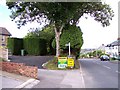
Signs for Shoot's Delph Farm and Crank Caverns
Image: © Raymond Knapman
Taken: 16 Jul 2010
0.16 miles
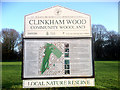
3
Clinkham Wood Recreation Ground, Elliott's Field
Image: © David Dixon
Taken: 22 Jan 2016
0.17 miles
4
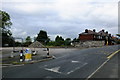
Moss Bank
The junction of Moss Bank Road with the A571 in the north of the grid square taken from the east.
Image: © Gary Rogers
Taken: 31 Aug 2005
0.19 miles
5

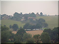
Billinge Hill
View of Billinge Hill from Martindale Rd just north of Carr Mill Dam
Image: © Galatas
Taken: 27 Jul 2009
0.21 miles
6
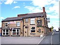
The Black Horse public house at Moss Bank
Image: © Raymond Knapman
Taken: 16 Jul 2010
0.22 miles
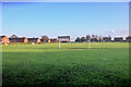
9
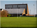
St Patrick's RC Church Clinkham Wood
Seen here from across the playing fields, the church was built in 1964 to serve a new housing estate, part of the post-war northern expansion of St Helens.
Image: © David Dixon
Taken: 22 Jan 2016
0.23 miles
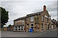
10
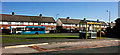
No More Black Horse
The site of the Black Horse pub. Demolished during the summer of 2013
Image: © Gary Rogers
Taken: 7 Oct 2013
0.24 miles